
A dependable GPS device turns an unfamiliar trail from a map exercise into a manageable route. Hikers need reliable positioning, readable controls, useful navigation data, and a battery design that suits the trip rather than the spec sheet. Backcountry routes also call for dependable satellite communication, while trips with dogs require tracking and training controls built into the same handheld. I’ve separated these roles below so hikers can choose the device that matches their route, group, and emergency plan.
The Shortlist At A Glance

Garmin GPSMAP 64 Worldwide GPS and GLONASS Receiver
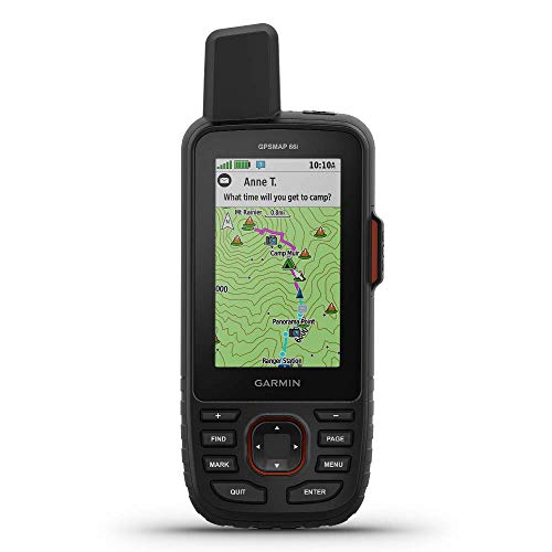
Garmin GPSMAP 66i GPS Handheld and Satellite Communicator Renewed

Dogtra PATHFINDER2 Compass Handheld with Existing Receiver

SPY SPOT GV53MG 4G LTE Hardwired GPS Tracker

ZOLEO Satellite Communicator Limestone

Dogtra PATHFINDER2 MINI Compass 4-Mile Dog Tracking System

Dogtra PATHFINDER2 Compass 9-Mile Dog Tracking System
More On The Choices That Made The List
Long-distance hikers often prefer familiar physical controls over touchscreen dependence, and that is where the GPSMAP 64 makes its case. Its 2.6-inch sunlight-readable display, quad-helix antenna, and support for both GPS and GLONASS satellites suit open country where maintaining a position matters most. Compared with the communication-focused GPSMAP 66i, this model concentrates on navigation, mapping, compass, and altitude functions.
The electronic compass gives direction without requiring continuous satellite lock, while the barometric altimeter tracks elevation through changing air pressure. For weekend backpackers, that combination offers useful redundancy during fog, descending trails, and uneven terrain. The 2.6-inch screen may feel modest for detailed map work, particularly for people with larger map-reading habits.
The Helpful Details
- Dual GPS and GLONASS reception improves position options beneath partial tree cover.
- The sunlight-readable display remains practical during exposed midday hikes.
- Wireless transfers reduce cable handling at a campsite or trailhead.
- One year of BirdsEye satellite imagery adds broad visual context beyond basic waypoints.
Worth Noting
- The screen is small for reviewing intricate routes, particularly in a moving group.
- Owners should protect the exposed handheld from prolonged moisture despite its suitability for rugged outdoor conditions.
- It does not provide the satellite messaging found in the GPSMAP 66i.
Key Specs
Made For
Weekend backpackers and hikers who prefer button-driven navigation will find this model especially straightforward.
A Better Fit Elsewhere
The Garmin GPSMAP 66i is a stronger fit for remote hikers who need two-way satellite communication.
The GPSMAP 66i broadens the role of a trail navigator by adding communication across areas without cellular coverage. Its 3-inch color screen is easier on route details than the GPSMAP 64’s 2.6-inch display, while TopoActive maps cover local terrain planning. The tradeoff is greater complexity and a satellite subscription for the communication service.
An interactive SOS can contact a 24-hour response center, and two-way messaging uses the Iridium satellite network. For solo hikers, section hikers, and small groups entering remote corridors, those functions create a direct communication link where cellular towers cannot. Renewed-condition shoppers should closely inspect the screen, controls, casing, and included accessories before relying on the unit.
Notable Upsides
- Satellite messaging gives the group a channel beyond cellular coverage.
- The larger display makes map review and route planning less cramped.
- TopoActive mapping supports preparation around local trails and terrain.
- Interactive SOS provides a defined communication channel for emergencies.
Trade Offs
- Satellite services require a subscription, adding a continuing ownership cost.
- The renewed designation calls for careful physical and functional inspection.
- Carrying more controls and a larger screen can reduce pack simplicity for fast hikers.
Feature Snapshot
Built With In Mind
Remote hikers and section hikers need communication as well as navigation, making this renewed GPSMAP 66i a purposeful fit.
Consider Something Else When
The Garmin GPSMAP 64 is the simpler choice for hikers who need navigation sensors but not satellite communication.
A phone-free handheld changes the rhythm of hiking with a dog that ranges beyond arm’s reach. This PATHFINDER2 compass supplies a 2-inch LCD, integrated direction sensing, live tracking access, and electronic-collar controls, but it does not come with the receiver needed for a complete setup. That requirement makes it a component for an established system rather than a straightforward first purchase.
Owners with the original connector can replace a damaged handheld while retaining their receiver and training setup. No subscription is required, which is a practical difference from cellular-dependent dog trackers. The limiting factor is compatibility: without the existing receiver, the display and collar controls have no complete operating setup.
Strong Points
- The 2-inch display gives dog direction and tracking information without a smartphone.
- Integrated compass and e-collar controls reduce the number of devices handled in brush.
- No subscription removes a recurring tracking expense.
Small Caveats
- An existing compatible PATHFINDER2 receiver is essential.
- Starting from scratch is more complicated than choosing the complete PATHFINDER2 MINI system.
- The compact display may require concentration when a fast-moving dog crosses the direction indicator.
Who Should Grab It
Hikers with a working PATHFINDER2 receiver who want a phone-free replacement handheld fit this accessory role.
Another Choice May Suit
The Dogtra PATHFINDER2 MINI Compass is more suitable for owners who need a complete dog-tracking and training system.
This tracker sits outside the normal hiking-device category because it monitors a vehicle rather than guiding a person on foot. Its purpose becomes relevant before a remote hike: locating a parked vehicle, monitoring a rental, or protecting a vehicle left unattended near the trailhead. The hardwired connection supports continuous operation without occupying a console charging port.
Position updates travel through the 4G LTE network, while the remote kill switch can disable engine starting through the associated app or web dashboard. That feature is valuable for theft deterrence, although installation involves connecting the tracker to the vehicle’s electrical system. A subscription is required for tracking and remote starter control, so recurring service should be considered alongside hardware and installation.
Everyday Wins
- Hardwiring supports persistent vehicle monitoring during longer absences.
- Remote starter control adds a practical layer of vehicle security.
- App and dashboard access suit both short errands and longer travel periods.
Practical Considerations
- Professional installation may be easier than routing wires through a vehicle cleanly.
- Cell coverage and subscription activation affect tracking availability.
- It does not provide hiking navigation or satellite rescue communication.
Quick Facts
The Right Fit
Drivers storing a vehicle near a trailhead or across long work periods will find this more useful than a conventional navigator.
Look Elsewhere When
The ZOLEO Satellite Communicator better serves hikers who need personal communication beyond cellular service.
ZOLEO takes a different route from a full-featured handheld navigator by using a paired smartphone as the main interface. Text messages and emails can travel over satellite, cellular, or Wi-Fi, allowing the device to use the available connection rather than limiting communication to one network type. That design reduces the number of standalone controls a hiker must learn.
The Safety Circle can keep designated contacts informed, making the communicator useful for group travel, extended routes, and outings beyond phone coverage. The honest limitation is its narrower standalone role: it does not replace the detailed topographic navigation offered by the Garmin GPSMAP 64. A subscription is also required, and battery management becomes essential for multi-day trips.
A Few Strong Suits
- Smartphone-based controls reduce the need to carry a second rugged handheld.
- Automatic connection selection supports communication across satellite, cellular, and Wi-Fi networks.
- Shared Safety Circle features suit families and organized hiking groups.
Details To Watch
- Subscription service adds a continuing communication expense.
- Phone dependence makes it less suitable for hikers who regularly travel without a smartphone.
- Standalone route-finding features are limited compared with a dedicated GPS handheld.
Who Will Love This
Group hikers who normally carry a phone and want lightweight satellite messaging will appreciate this approach.
Swap It Out When
The Garmin GPSMAP 66i is a better fit for hikers who want detailed offline navigation and communication controls on one device.
The PATHFINDER2 MINI puts dog location and electronic-collar controls into a phone-free handheld built for dogs weighing at least 15 pounds. Its 2-inch LCD and built-in compass provide a compact directional view, while rapid two-second location updates help a hiker follow changes in a dog’s movement. That is a meaningful distinction from a receiver-only accessory, because this model supports a complete setup.
Offline maps, a GPS fence, and expansion up to 21 dogs add useful field controls without a subscription. The four-mile range is the defining compromise, working well for local trails and open recreation areas where the dog remains within a manageable radius. The system cannot cover every large hunting territory, so terrain and roaming behavior deserve careful consideration.
What It Does Well
- Two-second updates make quick directional changes easier to follow.
- The handheld works independently from a phone during dense brush.
- Offline maps support trail use without cellular coverage.
- GPS fencing adds a configurable boundary for compatible dogs.
Possible Compromises
- Four-mile range may be limited across open or rolling terrain.
- The 15-pound minimum excludes many smaller companion dogs.
- The compact screen offers less visual detail than a modern phone map.
Product Snapshot
Best Suited To
Local hikers with medium or large dogs need responsive tracking and collar control without smartphone dependence.
Where A Sibling Pick Shines
The Dogtra PATHFINDER2 Compass 9-Mile system is more suitable for open-country routes where a dog may range farther.
Extra roaming room separates this PATHFINDER2 Compass from the four-mile MINI system. The nine-mile range gives a dog more room on open trails, hunting country, and wide recreation areas, reducing the likelihood that normal scouting exceeds the tracking radius. It is intended for dogs weighing 35 pounds or more, a limitation that reflects the collar and tracking system’s target size.
The 2-inch display, built-in compass, and two-second position updates preserve the phone-free experience established by the MINI model. Offline maps and GPS fencing support navigation and boundary control, while the system expands to as many as 21 dogs. Training controls remain close at hand, but the dense feature set rewards practice before entering a remote route.
What Earns Its Place
- Nine-mile tracking range accommodates dogs that roam farther from the handle.
- Rapid updates help track sudden direction changes across open terrain.
- Offline maps and GPS fencing reduce reliance on cellular service.
- The system supports multi-dog households without a subscription.
Where It May Fall Short
- The 35-pound minimum excludes smaller dogs.
- A nine-mile nominal range can be affected by terrain, vegetation, and other line-of-sight factors.
- Charging several dog collars requires planning during multi-day outings.
Core Details
Whose Shelf It Belongs On
Open-country hikers with dogs over 35 pounds gain the most useful balance of roaming room and direct field controls.
Reach For A Different Pick When
The Dogtra PATHFINDER2 MINI Compass is the better fit for dogs above 15 pounds on shorter, local routes.
Choosing A Device That Matches The Route
Navigation, Sensors, And Map Detail
A conventional hiking GPS should provide a readable display, stable positioning, and controls that remain usable in wet or cold conditions. Dual-constellation reception can help in wooded terrain, but battery life, route management, and waterproofing matter just as much during long days. Map detail and offline storage deserve priority for backpackers, while casual day hikers may accept a simpler feature set.
Communication Beyond Cellular Coverage
Satellite messaging and SOS features matter on routes without dependable cellular service. A subscription may be required, so hikers should account for activation, coverage, and battery management before departure. Devices such as the ZOLEO Satellite Communicator use a smartphone interface, while the Garmin GPSMAP 66i provides more dedicated navigation hardware.
Dog Tracking And Training Controls
Dog-focused systems need range, directional guidance, collar controls, and a display readable during movement. The specified range should match the animal’s normal roaming behavior rather than just the size of the local park. Dog weight requirements, offline map access, and multi-dog capacity also narrow the choice.
Setup Details That Shape Daily Use
Common Shopping Slip Ups
A large display can be less useful in dense brush, while a compact unit may feel cramped for detailed route review. Range, dog size, screen size, and satellite service should match the actual outing. Existing-system parts also need a compatible receiver, so incomplete bundles can be a costly surprise.
What The Higher Tier Buys
Premium hiking devices tend to add larger displays, communication functions, and more specialized sensors. Those additions help on remote routes, but they also increase cost, complexity, and charging demands. A dedicated navigation model remains sensible for local hikes, while a communicator earns its place when cellular gaps are a regular concern.
Frequently Asked Questions
Do I need a subscription for a hiking GPS?
It depends on the device. Conventional GPS navigation may work without one, while satellite messaging, SOS service, or cellular tracking often requires an active plan.
Can I use these devices without cellular coverage?
Dedicated GPS units can acquire satellite positions without cellular service. Communicators add messaging through satellite networks, although subscriptions and clear views of the sky remain important.
Which GPS is best for hiking with a dog?
Dog-focused systems provide directional tracking and e-collar controls. The correct range depends on local terrain and how far the dog normally roams.
Are renewed handheld GPS units suitable for backpacking?
A renewed unit can fit the role after careful inspection of its screen, buttons, casing, battery, and functions. The GPSMAP 66i’s satellite features still require the appropriate service plan.
What matters most on a long hiking trip?
Reliable positioning, readable controls, offline navigation, battery endurance, and a clear emergency plan matter more than extra features. Satellite communication is especially useful where cellular coverage disappears.