
Reliable navigation matters most on trails where cell service disappears, landmarks blur, and weather changes the route faster than expected. These options range from personal locator beacons and satellite communicators to marine distress lights and wrist-mounted Garmin navigators. I’ve organized them around the real questions hikers face: location tracking, two-way communication, emergency signaling, battery endurance, mapping, and pack weight.
The category isn’t as uniform as it first appears. Personal locator beacons provide a focused emergency-alert function, satellite messengers add messaging, and full GPS handhelds serve hikers who want detailed navigation throughout the day.
An Overview Of The Picks
ACR ResQFlare Electronic Distress E-Flare ACR 3966

ACR ResQFlare E-Flare Safety Kit for Marine Day and Night Use
ResQLink View GPS PLB and ResQFlare Outdoor Safety Kit
Garmin inReach Mini 2 Satellite Communicator Two-Way Text Bundle, Black

Garmin GPSMAP 67i Rugged Satellite GPS Handheld, Renewed

Garmin Foretrex 801 Wrist-Mounted Tactical GPS Bundle
ZOLEO Satellite Communicator (Slate Grey)
Taking A Closer Look At The Options
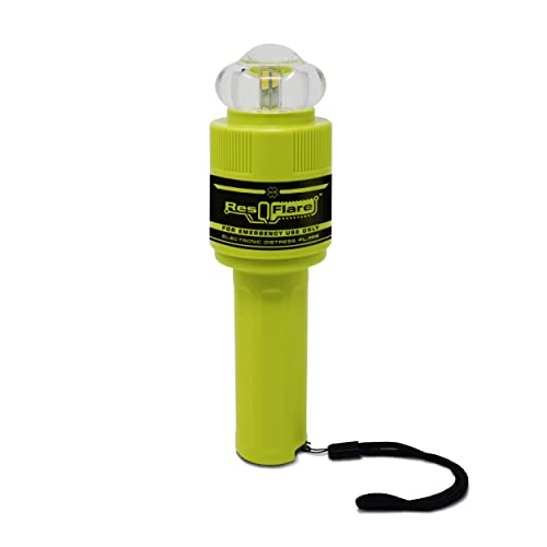
Watercraft need a visible emergency signal that remains useful after gear goes overboard, and the ACR ResQFlare 3966 focuses on that job. Its electronic light, distress flag, and floating construction suit boating emergencies more directly than a hiking GPS unit.
For a day hiker reaching a trail by boat, that visibility can be useful around shorelines and campsites. It does not display maps or transmit messages, so the honest fit remains an emergency signal rather than a navigation system.
The Helpful Details
- The light radiates in all directions, improving visibility around the vessel.
- Automatic righting helps it remain visible after entering the water.
- IP67 waterproofing supports exposure in wet marine conditions.
- The compact, lightweight profile takes little room in a safety kit.
Points To Keep In Mind
- It offers no mapping, coordinates, or two-way satellite communication.
- Routine inspection and storage in a dry, accessible compartment are important for long-term ownership.
Quick Facts
Made For Marine Emergencies
This device best serves boaters, anglers, and hikers traveling by water who need a compact visual distress signal.
Another Choice May Suit
The ResQLink View GPS PLB and ResQFlare Outdoor Safety Kit better serves hikers who also want GPS-linked emergency location capability.
Where the first ResQFlare is a compact individual signal, this safety kit adds a longer operating period for an extended marine incident. The stated 20-hour runtime is the defining advantage, giving a boater more time than the basic nighttime distress device offers.
It appears less relevant to a backpacker centered on trail maps, yet it earns its place for long days offshore or slow-moving rescue situations. Daytime use is addressed through the included flag, while the electronic light supplies the nighttime component.
What Helps Most
- Twenty hours of operation exceeds the stated nighttime regulatory runtime.
- Day and nighttime components create a more complete marine signal package.
- The waterproof housing handles spray and temporary submersion.
- All-direction illumination and automatic flotation improve failure visibility.
Worth Noting
- The kit remains a signal device without a map display or satellite messaging.
- Owners still need to keep the light and flag accessible rather than buried in stored equipment.
- Long runtime increases the importance of checking the device’s condition before each trip.
Built With In Mind
This kit suits offshore boaters, kayakers, and anglers who value extended signaling capability.
Consider Something Else When
The ACR ResQFlare Electronic Distress E-Flare ACR 3966 is the simpler option for owners wanting a smaller signal for shoreline and personal flotation emergencies.
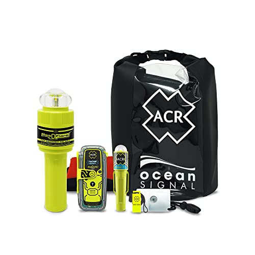
Hiking and boating share several emergency needs, and this package groups a ResQLink View personal locator beacon with visible-signaling tools. A personal locator beacon, or PLB, registers an alert and provides location information to emergency services after activation, without offering everyday map navigation.
The accompanying ResQFlare, C-Strobe H2O light, signal mirror, whistle, dry bag, and distress flag cover several layers of visibility and signaling. That makes this a practical starting kit for a remote hiking or paddling trip, although bundle weight may matter more to ultralight hikers.
Why It Works Well
- Combines GPS-linked emergency alerting with conventional signal tools.
- Serves both hikers and people combining trekking with boating.
- The dry bag helps protect paper maps and small electronics from moisture.
- Multiple signaling methods support different visibility and weather conditions.
Trade-Offs
- It is a safety bundle, not a replacement for a route-planning GPS.
- Carrying several accessories may conflict with minimalist pack-weight goals.
Who Will Love This
This package best suits hikers and paddlers who want one consolidated kit covering location alerts, lighting, signaling, and small-item protection.
A Better Fit Elsewhere
The Garmin inReach Mini 2 Satellite Communicator better serves backpackers who prioritize compactness and two-way messaging over physical signal accessories.
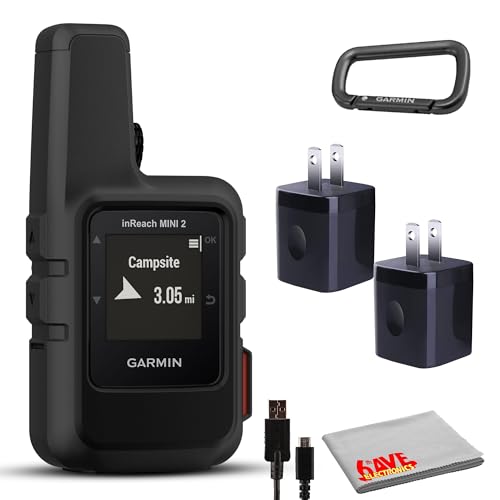
The Garmin inReach Mini 2 is the most straightforward satellite communicator here for a hiker moving beyond cellular coverage. It supports interactive SOS, two-way text messaging, and email through the Iridium network, covering both routine check-ins and emergency contact.
Its compact body is easier to justify in a daypack than the larger GPSMAP 67i, while the accessory bundle adds practical carry options. Compared with the ResQLink View PLB, it offers more communication flexibility, though a service plan is required for satellite functions.
Reasons It Performs
- Two-way satellite messages support family check-ins away from cell service.
- Interactive SOS adds location-linked emergency alerting.
- The compact enclosure reduces pack volume compared with a full handheld navigator.
- Iridium connectivity suits internationally remote travel.
Small Caveats
- Messaging and emergency features require a compatible service plan.
- Messages are concise rather than suited to lengthy conversation.
- Owners should protect the device from moisture despite its portable construction.
Made For Backpackers
This communicator fits solo hikers, backpackers, and small groups wanting compact satellite messaging and emergency alerts.
Where Another Pick Shines
The Garmin GPSMAP 67i better suits expedition hikers who want a full map display and satellite functions in one larger handheld.
The GPSMAP 67i combines conventional handheld mapping with inReach satellite communication for hikers who need both functions in one device. Mapping matters on long routes with junctions, dense forests, or poor visibility, while two-way messaging provides a channel for check-ins and emergency response.
This renewed listing may suit experienced outdoor users comfortable evaluating a pre-owned electronic device, but the condition of a particular unit deserves close attention. It is less natural for casual day hikes than the smaller inReach Mini 2, where pack volume matters more than display detail.
The Good Stuff
- Full mapping expands usefulness beyond emergency-only location reporting.
- Two-way messaging and interactive SOS are integrated into the handheld.
- The rugged design fits demanding trail and field conditions.
- Satellite connectivity supports remote routes and international travel.
Honest Caveats
- The larger enclosure takes more pack space than a compact communicator.
- Satellite services require an active plan.
- Refurbished inventory can vary in cosmetic condition and accessory completeness.
- Charging, buttons, screen, and ports deserve careful inspection before relying on the device.
The Right Fit
This renewed handheld best serves experienced hikers managing multi-day routes who want mapping and satellite communication together.
Look Elsewhere When
The Garmin inReach Mini 2 is the more natural choice for backpackers who want simple communication and emergency alerts in the smallest format.
Route checks become quicker with the Foretrex 801 strapped to the wrist, especially for fast hikers who prefer not to remove a device from a belt or pack. Multi-band reception improves positional accuracy by using multiple satellite frequency bands, while the monochrome display keeps navigation straightforward.
The stated 100-hour GPS runtime suits extended field use, although that figure depends on operating conditions and battery behavior. Tactical functions such as jumpmaster, stealth, and kill-switch modes target specialized navigation rather than ordinary trail touring, so the core appeal remains hands-free positioning.
Bright Spots
- Wrist mounting makes frequent position and route checks fast.
- Up to 100 hours in GPS mode supports long field days.
- Multi-band reception improves accuracy in challenging surroundings.
- The included strap, AAA batteries, and power bank simplify setup.
Less Ideal Details
- The small monochrome screen suits navigation but offers less visual detail than a large color handheld.
- Wearing a computer on the wrist may become uncomfortable over long periods.
- It lacks the satellite messaging and interactive SOS functions of the Garmin inReach models.
Who Should Grab It
The Foretrex 801 suits hikers and field users who want durable wrist navigation, long runtime, and quick route checks.
Reach For A Different Pick
The Garmin GPSMAP 67i is the stronger option for travelers who need detailed mapping plus two-way satellite communication.
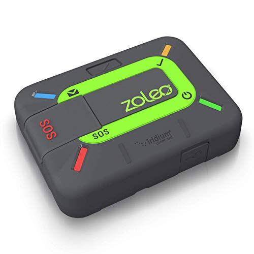
ZOLEO takes a different route from dedicated handhelds by using a paired smartphone as the primary interface. Hikers gain satellite text and email through the Iridium network plus interactive SOS with GPS location, while normal cellular or Wi-Fi connections take over where those networks are available.
That phone-based approach reduces the need to learn a small dedicated screen, making it approachable for people already comfortable with mobile apps. The compromise is dependence on both the communicator and a charged phone, so carrying a map remains sensible for route decisions.
Standout Benefits
- Smartphone-based operation provides a familiar messaging interface.
- Satellite texts and email work beyond cellular coverage.
- Interactive SOS can transmit the hiker’s GPS location.
- Automatic network selection may simplify remote communication.
Possible Compromises
- A compatible charged phone is needed to use the communicator’s main functions.
- The phone can become the weakest link during cold, wet, or long days.
- A service plan is required for satellite use.
- It provides communication rather than a dedicated topographic display.
Who It Suits Best
ZOLEO fits hikers who want satellite connectivity through a familiar smartphone interface instead of a traditional keypad device.
Swap It Out When
The Garmin inReach Mini 2 is a better fit for backpackers who prefer a self-contained device and less dependence on a paired phone.
Choosing Navigation For The Terrain
Start by separating everyday navigation from emergency communication. A full handheld keeps maps and route information visible throughout the hike, while a satellite communicator or PLB concentrates on contact and alerts beyond cellular coverage. The ResQLink View PLB and ResQFlare Outdoor Safety Kit sits between those needs, pairing location-based emergency signaling with conventional visual tools.
Mapping Versus Emergency Contact
Hikers following established trails may need nothing more than downloaded maps, yet remote routes make satellite features considerably more relevant. The Garmin GPSMAP 67i emphasizes mapping, while the Garmin inReach Mini 2 and ZOLEO concentrate on messages and SOS. I’d choose the full handheld for route complexity and a communicator for people whose primary concern is staying connected.
Form Factor And Battery Needs
Carry requirements deserve as much attention as features. The Foretrex 801 reduces screen checks to a wrist glance, and its stated 100-hour GPS runtime suits extended field work. Backpackers watching every ounce may prefer the smaller inReach Mini 2, while wrist wearers may find the larger handhelds more comfortable during extended use.
Marine And Multimodal Trips
A boat introduces water exposure and the need for visible signaling alongside electronic location equipment. Both ResQFlare choices automatically float and provide 360-degree light, making them stronger marine choices than the general hiking communicators. A mixed hiking-and-paddling trip can justify one of these signals plus a GPS-linked safety bundle.
Maps, Power And Service
A successful setup also needs a paper-map backup, dependable power management, and the correct subscription for any satellite service. I keep local navigation available even when a device handles messaging, since batteries, screen damage, and setup errors can interrupt electronic use. Familiarity matters too, and a complex device carried for the first time during a remote trip leaves little room for learning curves.
Avoiding Navigation Mix-Ups
Common Shopping Slip Ups
The biggest mistake is expecting one device to handle every function. A distress light, PLB, satellite communicator, and map-based handheld perform different jobs. I’d match each item to a specific gap rather than assume more buttons automatically create better preparation.
What The Higher Tier Buys
More money may buy a larger display, tougher enclosure, longer stated battery life, or the combination of mapping with satellite communication. The Garmin GPSMAP 67i spends that additional bulk on full handheld capability, while the Foretrex 801 prioritizes wrist access and endurance. The higher tier earns its place for demanding routes rather than casual outings.
Frequently Asked Questions
Are GPS hiking devices useful without cell service?
Yes. GPS can determine position without cellular service, while satellite communicators add messaging and emergency contact.
What is the difference between a PLB and a satellite communicator?
A PLB focuses on emergency location alerts, while a satellite communicator also supports two-way messages and routine check-ins.
Do I still need a paper map?
I recommend carrying one. Electronic devices can lose power, suffer screen damage, or present unfamiliar controls during an emergency.
Can wrist-mounted GPS devices handle hiking navigation?
They can show position and support navigation, though smaller screens may offer less detail than full handheld models.
Do satellite communicators work without a service plan?
Satellite messaging and SOS functions generally require an active plan, so verify coverage and subscription details before travel.
Closing Verdict
The best fit depends on the trip rather than a single feature list. Full handheld navigators suit detailed route work, compact communicators serve remote backpackers, and ResQFlare devices address visual marine emergencies. I’d match the device to expected terrain, communication needs, and carrying capacity, then practice its controls before leaving reliable coverage.