
Finding your way off the grid used to mean paper maps and a lot of guesswork. Today, a solid handheld or wrist-worn GPS keeps you oriented when your phone loses signal halfway up a ridge, and the price of admission has dropped enough that weekend hikers no longer need to splurge on flagship gear. The picks below lean toward affordable handheld units, satellite messengers that pair with your phone, and rugged watches that double as navigation tools. Each one earns its spot for a different reason: some prioritize battery life, others prioritize weight, and a few handle both jobs in one package.
The Lineup, Simplified
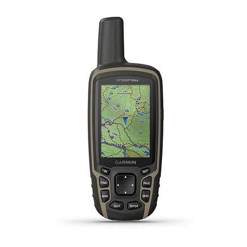
Garmin GPSMAP 64sx Handheld GPS Navigator
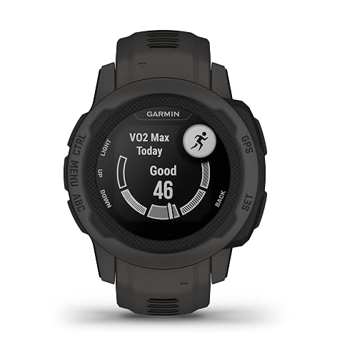
Garmin Instinct 2S Rugged Outdoor Watch (Graphite)
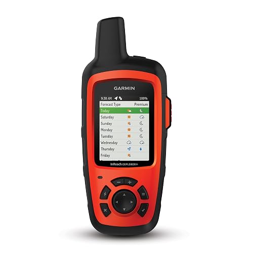
Garmin inReach Explorer+ Satellite Communicator

Garmin inReach Mini 2 Satellite Communicator

ZOLEO Satellite Communicator (Slate Grey)
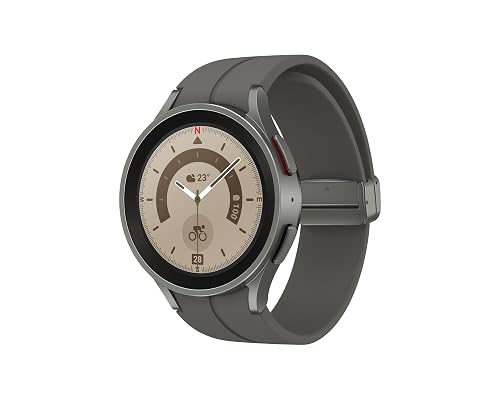
Samsung Galaxy Watch5 Pro 45mm GPS (Renewed)
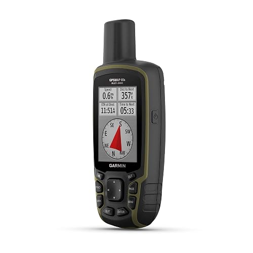
Garmin GPSMAP 65s Handheld with Multi-Band GPS
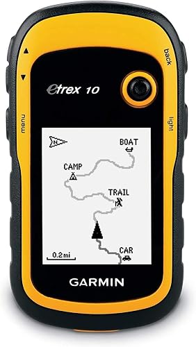
Garmin eTrex 10 Worldwide Handheld GPS Navigator
A Closer Look At Each Pick
The Garmin GPSMAP 64sx has been a quiet workhorse in the handheld world for years, and for good reason. It ships with TopoActive maps preloaded, so opening the box and heading to the trailhead feels like a near-zero-friction experience for backpackers planning multi-day routes.
Button-driven navigation matters more than newcomers expect: gloves, rain, and cold hands all play nicer with physical buttons than with touchscreens, which is exactly the case the 64sx is built around. The 2.6-inch color display stays readable in direct sun, and the rugged, water-resistant body shrugs off the kind of accidental drops that happen on rocky descents.
What Makes Sense
- TopoActive maps preloaded out of the box, removing the usual setup hurdle
- ABC sensors (altimeter, barometer, compass) for tracking weather shifts and elevation
- Physical buttons keep navigation usable with gloves or wet hands
- Wireless sharing of routes and waypoints with compatible Garmin units
Points To Keep In Mind
- Screen resolution feels modest next to newer smartphones
- Battery life is solid but AA cells mean carrying spares on long trips
Built With In Mind
Weekend backpackers who want reliable, button-driven navigation without subscription fees, especially those who cache maps ahead of a trip.
Look Elsewhere When
The Garmin GPSMAP 65s is the better match for hikers who frequently push into steep canyons where multi-band satellite tracking pays off in accuracy.
Compared with the 64sx, the Instinct 2S trades handheld bulk for wrist-worn convenience. It’s the kind of pick that disappears into a runner’s kit while still tracking pace, elevation, and route with multi-GNSS support, which means it pulls from several satellite networks rather than one for steadier positioning.
Trail runners and fast-packers tend to love this form factor because glances at the wrist beat pulling a phone or unit from a pack. TracBack routing on the watch nudges you home along the same breadcrumb trail you hiked in on, a small but confidence-building feature when fatigue sets in late in the day.
The Helpful Details
- Multi-GNSS support improves accuracy in tree cover and valleys
- TracBack routing guides a return along the original path
- Preloaded activity profiles cover running, biking, swimming, and more
- Smart notifications keep phone alerts in view without breaking stride
Honest Caveats
- Smaller case reads less clearly for users with larger wrists
- Detailed route planning still happens in the companion app, not on the watch
Feature Snapshot
Whose Shelf It Belongs On
Trail runners, fast-packers, and hikers who prefer a wrist-based form factor over clipping a handheld to a pack strap.
Reach For A Different Pick When
The Garmin eTrex 10 is a better fit for hikers who want a simple, no-subscription unit dedicated purely to breadcrumb navigation.
The inReach Explorer+ plays a different role than the 64sx or Instinct 2S. It pairs satellite messaging with GPS navigation, which means two-way text communication from anywhere on the Iridium network, provided an active subscription is in place.
Solo travelers who wander into remote valleys often pick this category for the SOS feature: a press of the button routes an alert through a global monitoring center, which is genuinely meaningful when cell service drops off the map. The unit also loads topographic maps for on-device navigation, so you don’t need a second device to read the terrain.
Practical Advantages
- Two-way text messaging over the Iridium satellite network
- Built-in SOS button routes alerts to a global monitoring center
- Preloaded topographic maps for on-device route reading
- Tracking intervals let contacts follow progress in real time
Trade-Offs To Consider
- Active satellite subscription is required for messaging and SOS
- Larger and heavier than the inReach Mini 2, which matters on long routes
Feature Card
Who Will Love This
Solo trekkers, international adventurers, and backcountry travelers whose routes cross long stretches of zero cell coverage.
A Better Fit Elsewhere
The Garmin inReach Mini 2 suits thru-hikers who count every gram and want similar SOS coverage in a much smaller body.
The inReach Mini 2 takes the same satellite backbone as the Explorer+ and shrinks it into something you can clip to a pack strap without thinking twice. Ultralight hikers tend to gravitate toward this form factor because the weight savings on a multi-week trip add up quickly.
TracBack routing on this unit follows the same logic as the Instinct 2S, retracing your outbound path so you don’t have to manually reverse a complicated route. The compact body also keeps the interface simple, which matters when you need to send a quick message or trigger an SOS in stressful conditions. Note that some jurisdictions regulate or prohibit satellite communicators, so it’s worth confirming local rules before relying on one.
A Favorable Mix
- Compact, lightweight build suits long-distance and ultralight kits
- Two-way global messaging plus interactive SOS capability
- TracBack routing handles return navigation automatically
- Water-resistant body handles rain, splashes, and stream crossings
Less Ideal Details
- Active satellite subscription required for full functionality
- Small screen can be tough to read in bright midday sun
The Right Fit
Thru-hikers, ultralight backpackers, and travelers who want satellite safety without the bulk of a full handheld unit.
Swap It Out When
The ZOLEO Satellite Communicator makes more sense for travelers who prefer composing messages on a paired smartphone screen instead of the device itself.
The ZOLEO takes a slightly different approach than the Garmin units: it pairs with your phone over Bluetooth, and you compose messages through the ZOLEO app instead of the device itself. For people who type faster on a phone keyboard than on a handheld unit, that ergonomic shift is a real selling point.
The device automatically picks the lowest-cost network available, moving between Iridium satellite, cellular, and Wi-Fi without forcing you to think about it. An SOS button on the unit itself routes an alert through a 24/7 emergency monitoring center along with your GPS location, even if you never open the app.
A Strong Showing
- Smartphone app makes typing long messages far more comfortable
- Automatic switching between satellite, cellular, and Wi-Fi networks
- Medical Assist adds a second tier of emergency contact options
- Compact size fits into a jacket pocket or pack lid pocket
Where It Is Less Suited
- Service plan required to send and receive messages
- Without a paired phone, the device alone is limited in features
Feature Facts
Best Suited To
Couples and small travel groups who already rely on their phones for messaging and want the same interface in the backcountry.
Not Your Match When
The Garmin inReach Explorer+ is the better call for hikers who want on-device topographic maps without depending on a paired phone.
The Galaxy Watch5 Pro steps into this list as a smartwatch that doubles as a trail tool. Its sapphire crystal display handles scrapes against rocks and pack straps noticeably better than typical smartwatch glass, which is reassuring on overgrown routes.
Voice or vibration-guided turn-by-turn navigation keeps eyes on the trail, and the long-lasting battery holds up through full days with GPS active. The 45mm case reads large on smaller wrists, but for trail use that footprint also means a more visible map screen at a glance. As a Renewed unit, the price lands below the original retail tier.
What Pays Off
- Sapphire crystal glass holds up well to outdoor scrapes
- Voice or vibration-guided turn-by-turn trail directions
- Long battery life supports full-day GPS-tracked outings
- Renewed pricing brings a flagship watch into tighter budgets
Points To Note
- Larger 45mm case may feel oversized on smaller wrists
- Renewed condition means cosmetic variability between units
Who Should Grab It
Smartwatch-first adventurers who want trail navigation, fitness tracking, and notifications in a single wrist-worn device.
Consider Something Else When
The Garmin Instinct 2S is a smarter pick for hikers who prioritize dedicated multi-GNSS tracking and longer battery life over smartwatch features.
The GPSMAP 65s builds on the 64sx with one meaningful upgrade: multi-band technology. In plain terms, multi-band receivers listen to two frequency ranges from each satellite, which helps the unit ignore signal reflections off cliffs, buildings, and dense canopy. For hikers in steep or forested terrain, that translates to noticeably steadier tracks.
Like the 64sx, this unit uses a button-operated design with a 2.6-inch color display and preloaded routable TopoActive maps. ABC sensors cover altimeter, barometer, and compass duties, while Bluetooth and ANT+ connectivity handle wireless sharing with compatible gear.
Standout Benefits
- Multi-band technology improves accuracy in tough terrain
- Expanded GNSS support tracks more satellite networks
- ABC sensors cover altimeter, barometer, and compass needs
- Wireless connectivity via Bluetooth and ANT+
Softer Spots
- Costs more than the 64sx for an upgrade that matters only in steep country
- AA batteries require spare management on multi-day trips
Feature Rundown
Made For
Alpine hikers, canyon travelers, and anyone who pushes into terrain where single-band units tend to drift or lose position.
Where Another Pick Suits Better
The Garmin GPSMAP 64sx is a more cost-effective fit for hikers sticking to well-trafficked trails where multi-band accuracy isn’t critical.
The eTrex 10 closes out the list as a no-frills option that has aged well. It skips color screens and preloaded topographic maps in favor of a 2.2-inch monochrome display and a worldwide basemap, which keeps the price low without removing core navigation capability.
Beginners and casual day hikers tend to appreciate how little the eTrex 10 demands: AA batteries last a long time, the button interface is straightforward, and Garmin Connect compatibility allows you to analyze and share routes after the trip. The trade-off is no expandable memory or advanced sensors, but for simple breadcrumb tracking, the unit still does the job.
Well-Handled Touches
- Worldwide basemap covers basic orientation across regions
- Long battery life from two AA cells
- Garmin Connect compatibility for post-trip route analysis
- Accessible price point for first-time GPS shoppers
Some Limits To Know
- Monochrome display shows less detail than color units
- No preloaded topographic maps out of the box
Key Product Details
Perfect Match For
Beginners and casual day hikers who want a simple, affordable handheld without subscriptions or steep learning curves.
Skip It When
The Garmin Instinct 2S is the better choice for runners and fast-packers who want wrist-worn GPS and activity profiles.
Picking The Right Trail GPS For Your Style
Start with where you actually hike, not what looks impressive on a spec sheet. Suburban day hikers can get away with a phone and a basic app, but anyone moving into remote canyons, dense forest, or above-treeline terrain benefits from a dedicated unit with multi-band or multi-GNSS reception. GNSS stands for Global Navigation Satellite System, a category that includes the U.S. GPS network along with Russia’s GLONASS, Europe’s Galileo, and others. Units that listen to multiple GNSS networks generally hold a tighter fix in challenging conditions.
Battery type matters more than people expect. Units running on AA batteries keep you in control of spares, while rechargeable units trade that flexibility for lighter packs. Plan around how many days you’ll be out, and consider whether you’ll have solar or USB charging along the way.
Subscriptions deserve a hard look. The Garmin inReach units and ZOLEO require active satellite plans to send messages and trigger SOS. If you only hike where cell service is reliable, a non-satellite handheld or wrist unit might serve you better for the cost. On the other hand, anyone heading into true wilderness gets meaningful value from a satellite link.
Form factor follows use case. Handheld units like the GPSMAP line clip to a pack strap and tend to have bigger screens and longer battery life. Wrist-worn options like the Instinct 2S trade screen real estate for always-on convenience. Satellite communicators like the inReach Mini 2 and ZOLEO usually don’t navigate much on their own but pair with phones or other devices to add a safety layer.
Map detail and storage round out the picture. Preloaded topographic maps save setup time but lock you to whatever region Garmin or the manufacturer chose to include. Expandable memory lets you load custom map sets, which matters for international trips or regions where base coverage is thin.
Where Shoppers Slip Up
A common trap is buying a unit with a beautiful color screen but no subscription plan for satellite messaging, then assuming they have SOS coverage in the backcountry. Most pure handheld units, including the GPSMAP line and eTrex 10, do not send emergency signals. For that capability, look at the inReach Explorer+, inReach Mini 2, or ZOLEO.
Another frequent mistake is overlooking jurisdiction rules. Some regions restrict or prohibit satellite communication devices, so confirming local regulations before depending on one is a small step that prevents bigger headaches.
When The Higher Tier Pays Off
Spending up typically buys multi-band receivers, longer battery life, topographic map coverage, and satellite messaging. For weekend hikers on established trails, the lower tier of the lineup handles the job. For anyone crossing into remote terrain or solo travel, the upgrade to multi-band GPS or a satellite communicator tends to pay back the price difference in confidence and safety margin.