
Heading off-grid, whether you’re staking a survey corner or checking in from a backcountry trail, calls for gear that knows exactly where you are. Handheld GPS devices have quietly become a multi-tool category, ranging from centimeter-accurate surveying rigs to pocket-size satellite messengers that fit on a carabiner. The right pick depends on the job: a roamer needs two-way texting and an SOS button, while a land surveyor needs tilt compensation and UHF radio range.
We focused on real-world use cases. Backcountry backpackers, mountain bikers tracking every climb, small-business owners keeping tabs on a fleet, and field surveyors working under tree canopy all want different things from a handheld unit. The ten picks below split cleanly into four groups: professional RTK (Real-Time Kinematic) surveying gear, satellite communicators for off-grid safety, cycling computers with serious navigation chops, and vehicle trackers that live in or on a car.
Check on AmazonA Fast Comparison Of The Options
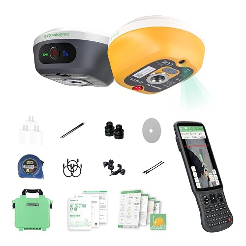
L1-AR GNSS RTK Base+Rover – RTK GPS Handheld Collector

Garmin inReach Mini 2 Satellite Communicator (Flame Red, Bundle)
Garmin 010-01879-00 inReach Mini Satellite Communicator (Orange)
Optimus OBD Plug-in Car GPS Tracker

Garmin inReach Mini 2 Satellite Communicator (Orange)
Garmin Edge 540 Cycling Computer Bundle
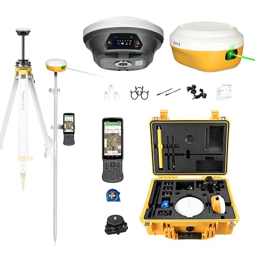
E1 Pro-L1 Laser GPS Rover RTK & Base Station

E1 Lite GNSS RTK Surveying Equipment

Optimus 3.0 GPS Tracker Bundle

Optimus Wired GPS Tracker for Vehicles
The Details Behind The Selections
Survey crews working under tree canopy or beside tall buildings know the frustration of losing RTK fix right when a corner shot matters. The L1-AR pairs a 1408-channel L1/L2 GNSS engine, which is the satellite signal processing hardware that tracks multiple frequencies across GPS, GLONASS, Galileo, BDS, QZSS, and SBAS constellations simultaneously, with a 5-second initialization time, so the rover comes up fast and stays locked through the kind of obstructed sky that ruins lesser gear. The integrated 2MP camera with a global shutter, meaning every pixel is read at the same instant so fast motion won’t smear the image, overlays virtual point guidance on the live view for stakeout work.
That AR stakeout feature turns a slow, paper-bound layout process into something closer to walking a paint line. You see the target point on the screen, you walk toward it, and the visual feedback tells you when you are over the spot. It is a workflow shift that pays for itself on any job with more than a handful of points.
Features That Help
- Multi-constellation L1/L2 tracking through GPS, GLONASS, Galileo, BDS, QZSS, and SBAS satellites for reliable fix in obstructed terrain.
- 5-second RTK initialization keeps field crews moving on tight schedules.
- AR visual stakeout via the built-in camera overlays design points onto the live view, simplifying layout walks.
- 120° tilt survey capability means you can collect points without leveling the pole, a real time-saver on uneven ground.
- 2cm accuracy in RTK mode is the industry baseline for boundary and topographic work.
Things To Consider
- Centimeter-grade work demands a clear sky view more often than the marketing suggests, so dense canopy still costs you fix time.
- The RTK workflow needs a correction source (base station or NTRIP, which is a network that streams correction data over the internet), so plan for that data connection on remote sites.
Key Specs
Made For
Surveying professionals and crew chiefs who run boundary, topo, or layout work and need visual stakeout to speed up field days.
Consider Something Else When
Backcountry hikers who simply want safety messaging should look at the Garmin inReach Mini 2 in this list instead, since surveying gear is overkill for trails.
The Mini 2 has earned its reputation as the go-to pocket satellite communicator for backpackers, hunters, and paddlers, and this Flame Red bundle keeps that core experience while adding a Deco Essentials 26-month extended protection plan on top of the manufacturer warranty. The unit sends and receives two-way text messages over the global Iridium network, a constellation of low-earth-orbit satellites that provide pole-to-pole signal coverage, and triggers an interactive SOS to a 24/7 emergency response team when things go wrong.
What makes the bundle worth considering is the accidental-damage coverage. Drops on granite, splash damage in a kayak spray skirt, the kind of incidents that happen once per trip, are covered with quick claims and no deductible. For anyone who actually uses their gear hard, the extra peace of mind is tangible.
What Works In Its Favor
- Palm-sized form clips to a pack strap or PFD (personal flotation device) without bulk, an upgrade over older brick-shaped units.
- Two-way texting over the Iridium network keeps you in touch where cell towers don’t reach.
- The 26-month extended protection plan covers accidental drops, spills, and breakdowns beyond the manufacturer window.
- Bluetooth pairing with a phone unlocks full keyboard typing and map navigation without upgrading to a larger unit.
Trade Offs
- An active satellite subscription is required for messaging and SOS features to function at all.
- Battery life drops noticeably in cold weather, so winter trips benefit from a USB power bank in the pack.
Who It Suits Best
Backcountry travelers and paddlers who want satellite safety plus meaningful accidental-damage coverage for multi-season use.
Look Elsewhere When
Cyclists tracking ride metrics will get more from the Garmin Edge 540 covered below, since its feature set is built around the bike, not the trail.
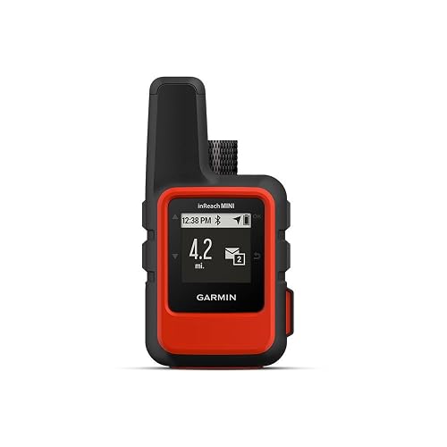
The original inReach Mini set the template for pocket satellite communicators, and the 010-01879-00 keeps that legacy alive with the same rugged, lightweight shell that disappears on a carabiner. Two-way text messaging runs through the Iridium network, and the SOS button connects to the GEOS 24/7 emergency response team that coordinates rescue dispatch worldwide. The hi-vis orange shell is easy to spot in a pack or a snow drift.
This is the right pick when weight matters more than feature depth. Ultralight hikers and bikepackers running week-long routes often prefer the original Mini form factor because every ounce counts. Bluetooth pairing routes phone notifications through the device for full message composition.
The Helpful Details
- Lightweight build adds minimal pack weight, which ultralight travelers care about on long routes.
- Two-way global Iridium messaging keeps communication open beyond cell range.
- Interactive SOS reaches a 24/7 emergency response team that coordinates actual rescue.
- Track-and-share feature posts location updates so trip followers can watch progress in real time.
Minor Gripes
- Satellite subscription is mandatory for any communication function.
- Smaller screen makes composing long messages tedious without phone pairing.
- Newer Mini 2 models offer better battery life and routing features than this first-generation unit.
Right Fit For
Minimalist backpackers and thru-hikers who prioritize weight savings over advanced navigation extras.
Skip It When
Anyone heading into serious terrain should consider the Garmin inReach Mini 2 below for its TracBack return routing and improved battery performance.
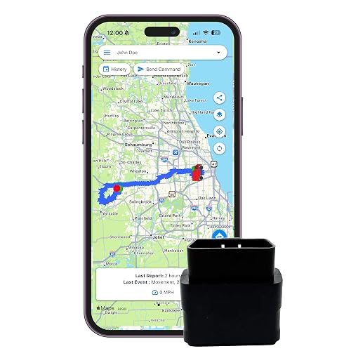
Vehicle tracking can get complicated fast, but the Optimus OBD unit removes every obstacle by plugging straight into the OBD-II port under the dash. That port, present in virtually every gasoline vehicle built since 1996, supplies power and lets the tracker wake up with the ignition. The setup is genuinely foolproof for anyone comfortable locating the port beneath the steering column.
Beyond location history, the platform pushes alerts for movement, speeding, and geofence crossings (virtual boundaries you draw on a map that trigger a notification when the vehicle enters or leaves), so a small business managing a few delivery vans can keep tabs without enterprise-grade software. The extension cable is included for vehicles with awkwardly positioned OBD ports.
Where It Excels
- True plug-and-play install: no wiring, no fuse taps, no professional help required.
- Geofence and speeding alerts keep a small fleet, or a teen driver, accountable in real time.
- 30-second default reporting with an upgrade path to 10-second intervals for sharper tracking.
- iOS, Android, and browser access covers every screen in the household.
Worth Noting
- A monthly subscription is mandatory, so the upfront cost is only part of the total expense.
- OBD port location is usually visible, meaning anyone in the cabin can unplug the device and disable tracking.
Best Suited To
Small-business owners running a few vehicles and parents wanting visibility into a new driver’s habits without a hardwired install.
Reach For A Different Pick When
Stealth tracking that hides from vehicle occupants calls for the Optimus 3.0 magnetic tracker covered later in this list.
The inReach Mini 2 refined everything that made the original Mini a backcountry staple, and the Orange trim keeps the high-visibility shell that stands out in a pack or a snow drift. TracBack routing is the standout feature for solo travelers: it navigates you back along the same track you hiked in on, which matters more than a fancy basemap when the fog rolls in and the trail markers vanish.
Two-way messaging and interactive SOS still run over the Iridium network, so coverage is genuinely global where regulations permit. Water resistance handles rain and splash without a second thought, and Bluetooth pairing with the Garmin Explore app on a phone unlocks full keyboard typing and trip planning.
Points In Its Favor
- TracBack routing reverses your outbound track to guide you home in low visibility.
- Compact, lightweight body clips to a pack strap without bulk.
- Interactive global SOS reaches a 24/7 emergency response team.
- Water-resistant housing handles wet weather and paddle-spray scenarios.
A Few Limitations
- Active satellite subscription is required for messaging and SOS.
- Some jurisdictions regulate satellite communicators, so check local rules before international trips.
- Navigation features are basic compared with mapping handhelds like the Garmin Montana line.
Who Should Grab It
Solo hikers, hunters, and overlanders who want reliable two-way messaging and a return-to-trail safety net in a pocketable package.
A Better Fit Elsewhere
Surveyors and mapping professionals should look at the SingularXYZ E1 Lite below for true centimeter RTK, which is in a different league from waypoint navigation.
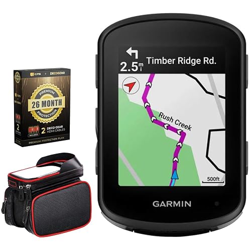
The Edge 540 sits in the sweet spot for serious cyclists who want adaptive coaching without the larger screen of the 840 series. Multi-band GNSS, meaning the unit reads multiple satellite frequency bands simultaneously, holds a tighter line through tree-lined climbs where single-band units drift, and ClimbPro ascent planning previews upcoming grades so you can pace a long climb properly. Stamina insights track your available energy in real time, which is genuinely useful on century rides.
The Deco Essentials bundle adds a bike frame cell phone mount and 26 months of extended protection. If a bar-end mount fails on a gravel descent and the computer takes a hit, the coverage handles the repair without a fight.
Where It Helps
- Multi-band GNSS keeps position accurate under tree cover and in urban canyons.
- Adaptive coaching responds to your recent training load and goals, not just static plans.
- ClimbPro previews grades ahead so long climbs can be paced properly.
- Stamina insights show real-time energy availability for endurance events.
Practical Considerations
- Bundled protection plan terms vary by retailer, so read what is actually covered before assuming everything is included.
- Smaller screen is a compromise for cyclists who like seeing large data fields at a glance.
Key Specs
Built With In Mind
Road and gravel cyclists who want adaptive training feedback and accurate line tracking without the larger Edge 840 footprint.
Swap It Out When
Hikers and backpackers should skip this and reach for the Garmin inReach Mini 2 above, since the Edge lacks satellite two-way messaging.
Survey crews regularly need to measure points they cannot physically reach: the far edge of a retention pond, a manhole across a multi-lane road, the corner of a roofline. The E1 Pro-L1 answers that problem by combining a laser rangefinder with the GNSS receiver in a single unit, so you can collect points up to 10 meters away without walking to them. The 1.1-inch HD screen cuts through direct sunlight better than older LCDs, which matters on long summer days.
Bluetooth, NFC, PPK (Post-Processed Kinematic, a method that refines positions after the fact using logged raw data), and NTRIP compatibility cover just about every workflow a modern crew runs. The included tribrach, which is the three-screw mounting plate that lets you level the base station precisely, means the kit arrives ready to set up rather than needing extra purchases.
Positive Points
- Laser-assisted measurement reaches inaccessible points up to 10m away.
- AR stakeout overlays design points on the live view for faster layout walks.
- 15km UHF radio range lets the base and rover stay connected across large job sites.
- Doubles as a base station for drone mapping workflows.
- Bundled tribrach removes an extra purchase for typical surveying setups.
Where It May Fall Short
- Laser accuracy drops in heavy rain or fog, so the hybrid benefit shrinks in poor weather.
- Full feature set requires familiarity with multiple software ecosystems, which lengthens onboarding for newer crew members.
Feature Snapshot
Whose Shelf It Belongs On
Surveying crews that regularly measure hard-to-reach points and want a hybrid tool that doubles as a drone mapping base.
Not Your Match When
Cyclists wanting ride data should consider the Garmin Edge 540 from earlier in this list instead, since surveying tools offer nothing for bike metrics.
Long field days separate useful survey gear from gear that runs out of battery at 2pm. The E1 Lite addresses that head-on with a 6700mAh battery that pushes past 20 hours of continuous operation, plus fast Type-C charging that refills quickly between sites. The IMU (Inertial Measurement Unit) initializes in 5 seconds and supports tilt measurements up to 60°, so you can collect points without stopping to level the pole on uneven ground.
The 10 to 15km UHF range is enough for most rural and suburban jobs without needing a cellular NTRIP connection. For crews working far from cell towers, that radio link keeps the base and rover connected without monthly data costs. Standard 5/8-inch thread poles mean you use your existing hardware rather than buying new accessories.
Useful Touches
- 20+ hour battery life covers a full day on a single charge.
- 5-second IMU initialization gets you ready to collect points quickly.
- 60° tilt survey lets you work without leveling the pole on rough terrain.
- 10 to 15km UHF range maintains base-rover link without cellular data.
- Standard 5/8″ thread compatibility works with existing pole setups.
Details To Watch
- Battery performance drops in extreme cold, so winter crews should plan for a power bank backup.
- 60° tilt is generous but not unlimited: very steep pole angles still introduce accuracy drift.
Perfect Match For
Field survey crews running long days without reliable recharging, especially in rural areas without cellular data coverage.
Another Choice May Suit
Solo hikers wanting satellite messaging should consider the Garmin inReach Mini 2 in this list, since this is professional surveying gear.
Sometimes you need tracking that nobody in the vehicle knows about. The Optimus 3.0 pairs a discreet GPS unit with a twin magnet case that holds firm to metal chassis components, so you can place it under a car or trailer frame and forget it is there. The 1-minute default reporting stretches battery life to roughly two months between charges.
Custom alerts by text or email keep you in the loop without opening an app, and reporting can be tightened to every 10 seconds for live-tracking moments. The monthly subscription is unavoidable, but the platform covers vehicles, trailers, machinery, and valuables through the same interface.
Real Benefits
- Twin magnet case attaches securely to metal surfaces without tools or brackets.
- Up to 2-month battery at 1-minute reporting stretches service intervals nicely.
- 10-second reporting upgrade is available for time-sensitive tracking.
- Custom text and email alerts cover movement, geofence, and low-battery events.
Practical Considerations
- Monthly subscription is required for any tracking function.
- Magnet mount only works on ferrous metal, so fiberglass or aluminum assets need different placement options.
- Battery life shrinks sharply if you tighten reporting to every 10 seconds.
The Right Fit
Owners tracking vehicles, trailers, or equipment without permanent installation, especially when stealth matters more than dashboard integration.
Where Another Pick Suits Better
Long-term fleet deployments benefit from the Optimus wired tracker covered next, since hardwiring removes battery management entirely.
Permanent vehicle tracking removes one of the bigger headaches of battery-powered units: the charging cycle. The Optimus wired tracker connects directly to the car’s battery with a two-wire install (positive and negative), drawing constant power from the electrical system. Once installed, it just runs.
The 30-second default reporting tracks every turn with enough detail for most fleet and family needs, with an upgrade to 10-second reporting for sharper accuracy. The subscription structure is straightforward and cancelable at any time, with no contract requirement or hidden fees.
What It Does Well
- Direct battery connection means no recharging or battery swaps once installed.
- Two-wire install is approachable for anyone comfortable with basic automotive wiring.
- 30-second default reporting covers most fleet and family tracking scenarios.
- No-contract subscription structure keeps total cost predictable.
Things To Weigh
- Wired connection means a brief power draw on the vehicle battery, which can matter for cars parked for weeks at a time.
- Hardwired installs are less portable: switching the unit between vehicles requires some rewiring effort.
Who Will Love This
Fleet operators and families wanting permanent, low-maintenance vehicle tracking without managing battery charge cycles.
Not Your Match When
Users who need to move the tracker between vehicles should pick the Optimus 3.0 magnetic unit above for tool-free redeployment.
What To Weigh Before Choosing Your Handheld GPS
Accuracy matters, but the kind of accuracy you need depends entirely on the job. Satellite communicators like the inReach Mini 2 rely on Iridium’s global constellation and provide meter-level positioning, which is fine for sharing your trailhead with family. Surveying systems like the SingularXYZ E1 Lite and L1-AR push toward centimeter-grade RTK, which is the precision land surveyors and engineers need for boundary work, and they cost considerably more because the hardware and correction services are specialized.
Battery life is the next big differentiator. Survey crews running 12-hour field days need the E1 Lite’s 6700mAh cell, while backpackers might rely on the inReach Mini 2’s modest runtime paired with a pocket power bank. Cyclists get the best of both worlds with the Edge 540, which charges between rides and runs a full century event.
Subscription models deserve a hard look too. Garmin satellite communicators require an active Iridium plan, which means monthly costs on top of the hardware purchase. Optimus vehicle trackers also run on subscription tiers. Tools like the SingularXYZ surveying gear only need a subscription if you choose NTRIP corrections, while UHF radio base-rover setups work without any ongoing fee. Make sure the total cost of ownership fits your budget before committing.
Finally, think about the environment where you’ll actually use the device. Cold weather cuts battery life noticeably. Wet conditions call for confirmed water resistance. Urban canyons and dense canopy challenge single-band GNSS, while multi-band receivers like the Edge 540 hold a tighter line through those obstructions. Matching the tool to your terrain avoids frustration on day one.
Key Considerations Across These Picks
Common Shopping Slip Ups
Picking the wrong category is the most common mistake. A satellite communicator cannot survey a property line, and an RTK rover cannot send an SOS from a backcountry trail. Decide first whether you need safety messaging, surveying accuracy, or vehicle tracking, then narrow within that category.
Another trap is ignoring subscription costs. The hardware price is only the entry fee for satellite communicators and most vehicle trackers. A device that looks affordable can cost more over a year than a higher-priced unit with no monthly fees.
Where The Extra Money Goes
In surveying gear, the premium tier buys multi-constellation tracking, tilt compensation, and faster initialization. Those features save real time in the field, but they only matter if you’re working under canopy or on uneven terrain. For open-sky jobs with long sight lines, an entry-level rover does the job.
In satellite communicators, the premium tier buys longer battery life, return-to-start routing, and better waterproofing. Those are safety upgrades worth the cost for serious backcountry travelers, while weekend hikers on established trails can step down a tier without real risk.
Frequently Asked Questions
What Is RTK In Handheld GPS Devices?
RTK stands for Real-Time Kinematic, a positioning method that uses a base station and a correction signal to achieve centimeter-level accuracy instead of the meter-level accuracy of standard GNSS. It’s most relevant for surveying and engineering work.
Do Handheld GPS Devices Work Without Cell Service?
Yes, the satellite communicators in this list use the Iridium satellite network rather than cell towers, so they work in remote areas. Surveying systems use UHF radio or NTRIP over cellular, depending on the setup.
How Accurate Are Consumer Handheld GPS Devices?
Standard satellite communicators provide roughly 5 to 10 meter accuracy, which is fine for navigation and safety. Surveying-grade units achieve 1 to 2 centimeter accuracy in RTK mode, which is the standard for professional boundary and topographic work.
Can Handheld GPS Devices Send SOS Alerts?
The Garmin inReach models in this list connect to the GEOS 24/7 emergency response team for interactive SOS messaging, but the surveying and cycling units do not include that feature. Check before relying on any device for backcountry safety.
Do Vehicle GPS Trackers Require Monthly Fees?
Most trackers, including the Optimus units covered here, run on monthly subscriptions to cover cellular data and platform access. Hardware-only options exist but usually lack live tracking and alert features.
Bottom Line
The right handheld GPS device depends entirely on what you’re doing with it. Surveying professionals should look closely at the SingularXYZ L1-AR or E1 series for centimeter accuracy and tilt compensation. Backcountry safety calls for a Garmin inReach Mini 2 with two-way messaging and SOS. Cyclists wanting real-time coaching belong on the Edge 540, and anyone tracking vehicles will find a fit among the Optimus units. Match the tool to the terrain, and the rest takes care of itself.