
Your phone dies somewhere past the third mile. The trail fork splits under a canopy that swallows satellite signals. You’re setting fence posts in a pasture and need accuracy to the inch, not the row. Handheld GPS gear exists for exactly these moments, and the right tool depends entirely on what “lost” or “off-grid” looks like in your life.
A Quick View Of The Lineup
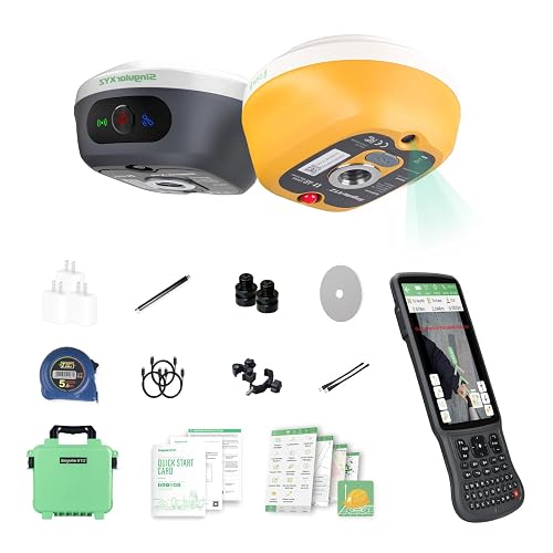
SingularXYZ L1-AR GNSS RTK Base+Rover Survey Collector

Dakota Digital GPS-50-2 Speed Sensor & BIM Module
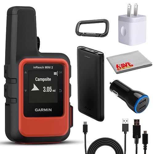
Garmin inReach Mini 2 Satellite Communicator Bundle
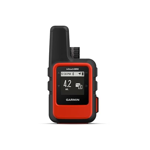
Garmin inReach Mini Satellite Communicator (Orange)
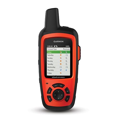
Garmin inReach Explorer+ with Topo Maps and GPS

Garmin inReach Mini 2 Satellite Communicator (Orange)
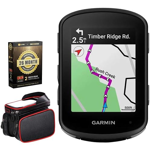
Garmin Edge 540 Cycling Computer Bundle
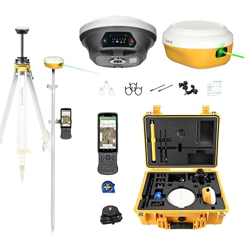
SingularXYZ E1 Pro-L1 Laser RTK Survey System

SingularXYZ E1 Lite GNSS RTK Surveying System
Why These Options Stand Out
Survey crews who stake out foundations, utilities, or fence lines need more than a hiking GPS, and the L1-AR sits firmly in that professional tier. Unlike the satellite communicators reviewed later, this unit is built around real-time kinematic (RTK) positioning, a method that uses a fixed base station and a moving rover to correct satellite data down to roughly two centimeters of horizontal accuracy.
The AR visual stakeout is the most distinctive feature here. A global-shutter camera (a sensor that captures the whole frame at once, avoiding the warped geometry of cheaper rolling-shutter sensors) overlays virtual guidance points on the live view, so a crew member can literally walk toward an arrow on the screen instead of staring at coordinate readouts. For tight urban job sites where every foot matters, that’s a real workflow shift rather than a marketing flourish.
Positive Points
- 1408-channel engine tracks GPS, GLONASS, Galileo, BDS, QZSS, and SBAS satellites simultaneously, which matters under tree cover or near tall buildings where signal diversity keeps a fix alive.
- Five-second RTK initialization means less downtime when moving between setup points.
- Up to 120° tilt survey lets crews measure points without leveling the pole, shaving real minutes off repetitive layouts.
- Camera-based stakeout reduces the chance of walking to the wrong offset on busy sites.
Trade-Offs Worth Weighing
- RTK accuracy depends on a clear radio link between base and rover; dense tree canopy or long distances can degrade the correction stream.
- Professional surveying software typically requires training and a learning curve that weekend users may find steep.
- Carrying both base and rover adds pack weight compared with a stand-alone handheld GPS.
Key Specs
Right Fit For
Licensed surveyors, civil-engineering crews, and serious contractors who stake out sites regularly and already own or plan to buy base-and-rover workflows.
Consider Something Else When
A weekend backpacker who just needs two-way satellite messaging should look at the Garmin inReach Mini 2 reviewed later, since RTK gear is overkill for trail navigation.
The Dakota Digital GPS-50-2 is a different animal from everything else on this list. It’s not a trail companion or a survey tool. It’s a vehicle-grade GPS receiver that feeds speed, heading, and compass data into Dakota Digital dashboards, BIM modules, and aftermarket instrument systems. Think hot-rods, custom motorcycles, and restomods where a mechanical speedometer cable just won’t fit.
Compared with the SingularXYZ units reviewed earlier, this module isn’t about centimeter accuracy. It’s about repeatable road-speed information that doesn’t drift with tire size or gear changes. Once it’s calibrated, swapping rear-end ratios or wheel diameter won’t throw off the speedometer readout.
Reasons It Performs
- GPS-based speed eliminates the need to recalibrate when gearing or tire size changes.
- Integrated compass output adds directional data for digital dash layouts that display heading.
- BIM (Bus Interface Module) compatibility lets it feed multiple Dakota Digital instruments from a single antenna feed.
Points To Keep In Mind
- This is a component, not a standalone GPS, so it only makes sense inside a Dakota Digital system.
- GPS antennas need a clear view of the sky; mounting inside a metal dash enclosure can weaken signal lock.
Built With In Mind
Custom-car builders, motorcycle fabricators, and restomod shops already running Dakota Digital instrumentation who want accurate, calibration-free road speed.
Look Elsewhere When
Anyone needing a handheld trail unit should skip this entirely and consider the Garmin inReach Explorer+ reviewed later in this roundup.
The Flame Red inReach Mini 2 already covers the basics of two-way satellite messaging and SOS alerts, but this bundle version layers in the supporting kit that backcountry travelers usually end up buying separately: a USB-C cable, car charger, cleaning cloth, and a portable battery bank. For someone starting from scratch, that consolidation removes the trial-and-error of matching cables and chargers.
Unlike the survey-grade tools reviewed earlier, this is a palm-sized safety device. It uses the Iridium satellite network (a constellation of low-Earth-orbit satellites that provides truly global coverage, including the poles) to send and receive text messages where cell towers don’t reach, and it pings a 24/7 emergency response center if you trigger the SOS button. It’s the kind of gear that sits in a pack for months untouched and becomes indispensable the one time conditions turn ugly.
Noteworthy Benefits
- Bundle saves the hassle of sourcing a compatible charging cable and external battery separately.
- Compact footprint keeps it pocket-friendly for fast-and-light trips.
- Interactive two-way messaging helps you coordinate a rescue rather than just broadcasting a beacon.
- Pairs over Bluetooth with a phone for easier typing and map viewing through the Garmin app.
Honest Caveats
- An active satellite subscription is required, which adds an ongoing cost beyond the upfront price.
- Some jurisdictions regulate or restrict satellite communicator ownership, so travelers should check local rules before relying on one abroad.
Who Should Grab It
Backpackers, paddlers, and overlanders who want a ready-to-go satellite safety kit without piecing accessories together one at a time.
A Better Fit Elsewhere
A solo ultralight hiker who already owns a battery bank and just needs the communicator should pick the plain Garmin inReach Mini 2 (orange) reviewed below.
The original inReach Mini is the device that made satellite communicators a realistic piece of gear for weekend hikers rather than just expedition climbers. It’s small enough to clip to a pack strap, light enough to forget about, and rugged enough to survive a tumble on talus. For anyone whose biggest concern is summoning help from a place without cell service, this unit gets the job done with no fuss.
Pair it with a phone over Bluetooth and the Garmin Explore app handles the typing and tracking, which matters because the on-device screen is tiny. Compared with the newer Mini 2 reviewed below, this model ships without TracBack routing, so getting home still requires some map-reading on your end.
The Good Stuff
- Truly pocket-sized form factor for fast-and-light packing.
- Two-way text messaging via the Iridium network covers the backcountry globe.
- Bluetooth pairing offloads message composition to a phone app.
Small Caveats
- Older-generation battery life is shorter than the Mini 2’s.
- Subscription fees apply for any satellite service.
Made For
Solo travelers heading into areas without cell coverage who want a lightweight lifeline more than a navigation computer.
Swap It Out When
Multi-day trekkers who want navigation aids like TracBack routing will get more from the Garmin inReach Mini 2 (orange) reviewed next.
Where the inReach Mini models focus on communication, the Explorer+ adds a real navigation layer: preloaded topographic maps (detailed terrain charts showing contour lines, elevation, and trail features), an on-board compass, and route planning that doesn’t require a paired phone. For someone heading out for a week or more, that integrated approach is the difference between carrying one device and three.
Compared with the SingularXYZ survey units earlier, this is firmly a recreational tool. It’s accurate to a few meters rather than a few centimeters, but for finding a campsite in dense forest or following a ridge line in fog, that’s plenty.
Useful Strengths
- Preloaded topo maps give terrain context without a phone or external download.
- Built-in compass and barometric altimeter round out the navigation toolkit.
- Two-way satellite messaging plus SOS on the Iridium network handles the safety side.
Things To Consider
- Heavier and bulkier than the Mini-series communicators.
- Subscription required for any satellite messaging features.
- Screen is small for extended map reading compared with a modern smartphone.
Quick Facts
Whose Shelf It Belongs On
Multi-day backpackers and remote-trip leaders who want navigation and satellite safety in one device rather than two.
Another Choice May Suit
Anyone prioritizing pack weight above all else should pick the Garmin inReach Mini 2 (orange) reviewed next.
The Mini 2 refines everything the original Mini started. Battery life stretches longer, the internal compass hardware is more responsive, and TracBack routing lets you retrace your breadcrumb track back to a trailhead without a phone. For trail runners, hunters, and anyone moving fast through unfamiliar terrain, that return-home feature is worth the upgrade on its own.
It still relies on the same Iridium network as the older inReach models reviewed earlier, and you still need an active subscription to use it for messaging. Think of it as the polished second generation rather than a category overhaul.
Where It Helps
- TracBack routing navigates you back along your recorded track.
- Water-resistant build shrugs off rain and stream crossings.
- Two-way messaging and interactive SOS on the Iridium network.
Less-Strong Areas
- Subscription plans vary, so ongoing costs deserve a budget line.
- Tiny on-device screen makes detailed map reading impractical.
Best Suited To
Trail runners, hunters, and day-trippers who want a compact communicator with reliable return-to-trailhead routing.
Reach For A Different Pick When
Anyone planning multi-day navigation with on-board topo maps should consider the Garmin inReach Explorer+ instead.
The Edge 540 isn’t a handheld in the hiking sense, but it lives in the same GPS family and serves riders who care about positioning data. It adds multi-band GNSS (a receiver that listens to multiple satellite frequency bands at once, which improves accuracy in tough signal environments) along with adaptive coaching and ClimbPro ascent planning that previews upcoming climbs.
This bundle pairs the head unit with a Deco Essentials phone mount and an extended protection plan, which simplifies the setup for someone starting from scratch on their cockpit.
Useful Touches
- Stamina insights help you pace long efforts before you bonk.
- Multi-band GNSS holds a tight line under tree cover or between tall buildings.
- Bundle ships with a phone mount, so you can run navigation on a paired device too.
Practical Considerations
- Full feature set rewards riders who dig into Garmin’s training ecosystem.
- Battery life drops fast with navigation screens and sensors running.
Perfect Match For
Road and gravel cyclists who train with structured workouts and want climb-by-climb pacing data.
Skip It When
Commuters who just want basic ride logging are better served by a simpler cycle computer or a phone app.
The E1 Pro-L1 takes the L1-AR concept covered earlier and bolts on a laser distance module. The integrated laser can measure points you can’t physically walk to, such as the top of a wall or the far side of a hazard, up to about ten meters away. For surveying crews that frequently face inaccessible targets, that hybrid laser-plus-GNSS approach saves a lot of ladder work.
It also doubles as a base station for drones, which makes it useful for pilots running photogrammetry missions (aerial surveys that stitch overlapping photos into 3D maps or measurements). The included tribrach keeps the base level on uneven ground, and the 1.1-inch HD touchscreen stays readable in direct sun, which sounds trivial until you’ve squinted at a washed-out screen on a job site.
Real Benefits
- Laser ranging reaches points the rover pole can’t touch.
- Works as a base station for aerial mapping workflows.
- 15 km UHF radio link (ultra-high-frequency wireless used to transmit RTK corrections from the base to the rover) covers large job sites without cellular coverage.
Details To Watch
- Laser ranging accuracy drops beyond the rated distance and in dusty or foggy air.
- Survey software learning curve remains steep for first-time users.
At A Glance
Who Will Love This
Surveying firms and drone-mapping pilots who need a versatile base-and-rover system with laser-assisted measurement.
Where A Sibling Pick Shines
Crews on extended battery-only days should look at the SingularXYZ E1 Lite reviewed next, which prioritizes endurance over the laser module.
The E1 Lite strips back the extras to focus on what field surveyors actually need on long days: a 6700 mAh battery that pushes past 20 hours of continuous rover use, fast Type-C charging between jobs, and the same 1408-channel engine found in the higher-end SingularXYZ units. The IMU (inertial measurement unit, a sensor that tracks tilt and orientation) supports tilt-compensated measurements up to 60° without leveling the pole.
It runs cooler on the spec sheet than the laser-equipped E1 Pro reviewed earlier, and for crews who don’t need laser ranging, the trade is a meaningful battery gain. UHF range stretches 10 to 15 km depending on terrain, which covers most rural job sites without depending on cellular networks.
The Case For It
- All-day battery life eliminates midday charging on remote jobs.
- IMU tilt compensation speeds up point collection in uneven terrain.
- Compatible with standard 5/8″ pole threads, so it drops into existing kit.
Possible Compromises
- No laser module means inaccessible points still need alternate methods.
- UHF performance varies with terrain; dense forest or heavy urban density may reduce the practical range.
Feature Snapshot
The Right Fit
Field surveyors working long shifts in remote areas who value battery endurance over fancy measurement add-ons.
Not Your Match When
Crews that regularly need to measure inaccessible points should pick the SingularXYZ E1 Pro-L1 reviewed above instead.
What To Weigh Before Picking a Handheld Gps
Accuracy matters, but it isn’t a single dial you crank up. Survey-grade RTK gear offers centimeter-level positioning through a base-and-rover setup, while recreational handhelds typically resolve within a few meters, which is plenty for finding a campsite but useless for staking a property line.
Network coverage is the other big fork. Devices using the Iridium satellite network, like the Garmin inReach line, give you true global coverage for two-way text and SOS. GNSS-only units rely on multiple satellite constellations (the families of navigation satellites orbiting Earth, including GPS, GLONASS, Galileo, and BeiDou) but need a clear sky view and no relay subscription. Match the network to where you actually go.
Battery life and charging style quietly shape ownership. A 20-hour rover battery means an overnight top-up is fine; a 10-hour unit demands a midday plan. USB-C fast charging has become table stakes for modern gear, but accessories and cables still vary by manufacturer.
Finally, consider ecosystem and subscription costs. Garmin’s satellite communicators require an active plan to do anything beyond basic tracking. RTK survey gear often pairs with proprietary software that rewards time invested in training. Buying hardware is the first step; budgeting for ongoing service and learning is part of the real total.
Key Considerations Across These Picks
Mistakes Worth Dodging
Choosing a recreational handheld for a survey job is the most common slip. Centimeter accuracy and RTK corrections don’t appear in a hiking GPS, no matter how good its trail maps look. The reverse is also true: dragging a base-and-rover system onto a weekend loop is wasted weight and money.
A subtler trap is ignoring subscription and accessory costs. Satellite communicators need active plans, and survey gear often requires software licenses or radio setup. Budget for those line items up front so the gear stays useful after the first month.
What The Higher Tier Buys
Spending more on the survey-grade SingularXYZ units buys genuine professional accuracy, faster initialization under tree cover, and tools like AR stakeout or laser ranging that change how a crew works. For a one-off property pin, the upgrade isn’t worth it. For a working surveying firm, the time saved on every job compounds quickly.
The same logic applies to Garmin’s Explorer+ over the Mini line: the price gap funds on-board topo maps and a real navigation screen. Long-trip users recover that difference in fewer dead-ended evenings and faster route planning.
Frequently Asked Questions
What is RTK GPS, and who actually needs it?
RTK stands for real-time kinematic, a method that uses a fixed base station to send correction data to a moving rover, trimming satellite-position errors down to about one or two centimeters. Surveyors, engineers, and serious mappers need it. Most hikers and backpackers do not.
Do satellite communicators work without cell service?
Yes. Devices like the Garmin inReach Mini 2 use the Iridium satellite network, which provides coverage far beyond cell towers. You need an active subscription plan for messaging and SOS features, but no cellular signal is required.
Can a cycling computer like the Edge 540 replace a handheld GPS?
For riding, it does the job well, with multi-band GNSS and structured training data. Off the bike, it lacks the rugged form factor and satellite-messaging features of the inReach line, so it isn’t a full substitute for backcountry use.
How many satellites do modern receivers actually use?
Higher-end units, including the SingularXYZ models reviewed here, track 1408 channels across GPS, GLONASS, Galileo, BeiDou, QZSS, and SBAS. More channels mean stronger fixes in tough environments like canyons or urban cores.
Is tilt-compensated surveying accurate enough for legal boundaries?
Tilt survey is excellent for layout and topographic capture, but licensed boundary surveys in many jurisdictions still require level setups for legal documents. Check local standards before using tilt data on a plat.
Wrap Up
The right handheld GPS depends less on which device leads a spec sheet and more on the terrain you actually cross. Weekend backpackers will lean on a Garmin inReach for safety messaging; survey crews will lean on a SingularXYZ RTK system for accurate layout; custom-car builders will lean on the Dakota Digital module for clean dashboard data. Match the tool to the trail, and the rest tends to take care of itself.