
A reliable handheld GPS changes how you work and play outside. Whether you are staking out a fence line on a rural property, mapping a trail before sunset, or coordinating emergency comms from a remote ridge, the right device cuts guesswork and keeps you on track. The ten picks below split roughly into two camps: precision RTK survey gear for land professionals, and compact satellite communicators for hikers, hunters, and weekend explorers. Match your terrain, your tolerance for setup, and your typical trip length, and the rest gets easy.
A Quick View Of The Lineup
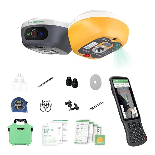
SingularXYZ L1-AR GNSS RTK Base+Rover GPS Handheld Collector

SingularXYZ E1 Lite GNSS RTK GPS Surveying Equipment

Dakota Digital GPS Interface Speed Sensor / Compass Sender GPS-50-2
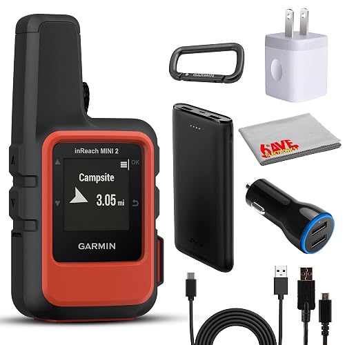
Garmin inReach Mini 2 Satellite Communicator (Flame Red) Bundle
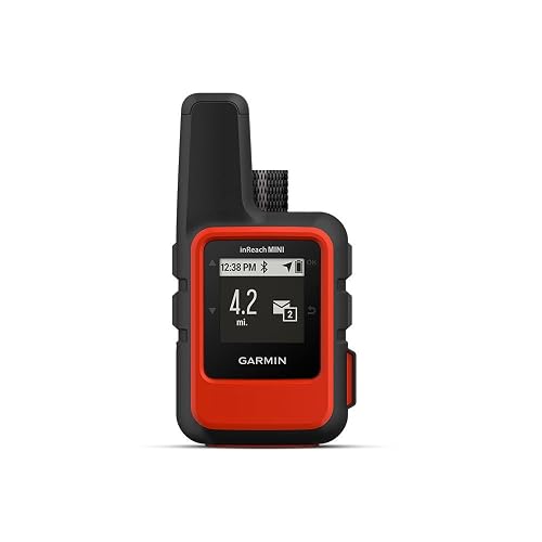
Garmin inReach Mini Satellite Communicator (Orange)
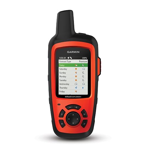
Garmin inReach Explorer+ Handheld Satellite Communicator with Topo Maps

Garmin inReach Mini 2 Satellite Communicator (Orange)
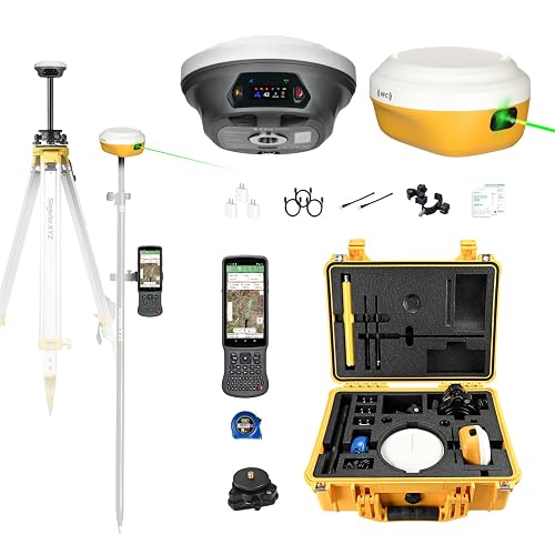
SingularXYZ E1 Pro-L1 Laser GPS Rover RTK & Base Station System

SingularXYZ E1 Lite GNSS RTK Surveying Equipment with IMU
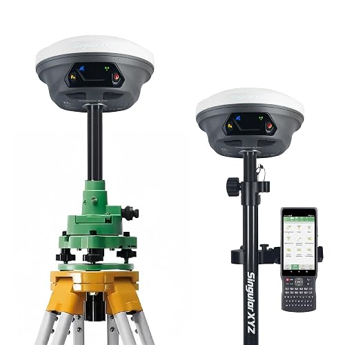
SingularXYZ E1 GNSS Survey Equipment RTK GPS with IMU
More Details On Our Top Picks
The SingularXYZ L1-AR feels purpose-built for survey crews who want a visual workflow on top of traditional RTK. A 1408-channel GNSS engine (the chip that talks to multiple satellite constellations at once) supports GPS, GLONASS, Galileo, BDS, QZSS, and SBAS, which matters when you set up next to a tree line or in a tight urban alley where signals bounce around.
The AR stakeout feature overlays a virtual point on the live camera view, so instead of staring at coordinate readouts you walk toward an arrow on the screen. Compared with the SingularXYZ E1 Lite below, this unit trades the IMU tilt sensor for camera-based guidance, which lands a different kind of user: visual learners and crews that stake out fence corners or utility markers in messy terrain.
The Good Stuff
- 2-centimeter horizontal accuracy with quick 5-second initialization in open sky.
- 120-degree tilt survey lets you measure without perfectly leveling the pole.
- Global shutter 2 MP camera holds up under mixed lighting, reducing motion blur when you walk.
- Multi-constellation tracking keeps a fix in tree canopy and urban canyons.
Worth Noting
- AR stakeout works best in daylight, so dawn and dusk sessions may feel slower.
- Higher channel count and camera hardware demand more battery than simpler rovers.
Key Specs
Made For
Crews that stake out points visually and want a faster layout workflow on site.
Consider Something Else When
Solo surveyors who need to measure off-pole points should look at the SingularXYZ E1 Pro-L1, which adds a laser for unreachable targets.
The E1 Lite arrives ready to work, with surveying software pre-installed on the handheld collector and a permanently valid license. That alone saves a half-day of setup for new owners, which is the kind of friction most crews do not want after unboxing gear at the truck.
Its 1408-channel engine handles the usual six satellite constellations and locks fixed solutions in seconds, even around tree cover. FCC certification matters when you operate in regulated jurisdictions. Pair it with a standard 5/8-inch thread range pole and you have a straightforward kit for land boundary, topographic, and CORS-corrected mapping work.
Notable Gains
- Pre-installed software eliminates a setup step on first use.
- Fast fixed RTK solutions under tree canopy and urban canyons.
- Standard 5/8-inch thread fits most existing range poles.
- FCC certification suits regulated job sites.
- Compatible with CORS networks for centimeter-grade correction.
Trade Offs
- No tilt sensor, so leveling the pole matters for off-center shots.
- SC260 collector is solid but lacks the camera-based AR workflow of the L1-AR.
Whose Shelf It Belongs On
Land surveyors and small firms who want a turnkey rover-and-collector pair out of the box.
Where Another Pick Suits Better
Hikers looking for a two-way satellite messenger should pick the Garmin inReach Mini 2 instead.
This Dakota Digital module lives in a different world from the RTK surveyors above, but it still belongs on a GPS handheld roundup because it sits in your dash, not in your hand. The GPS-50-2 pulls true ground speed, heading, and location data, then feeds it to a compatible Dakota Digital instrument system for clean, accurate readouts.
For restomod builders and custom dashboard shops, this sensor replaces the guessing game that comes with mismatched gear ratios and tire size swaps. You mount it once, calibrate it through the BIM module, and the speedometer reads correctly regardless of rear-end changes.
Key Advantages
- True GPS-derived speed eliminates speedometer errors after gear or tire changes.
- Compass heading data feeds directly into supported Dakota Digital systems.
- BIM module simplifies integration with the brand’s instrument clusters.
Some Limits To Know
- Works only with compatible Dakota Digital displays, limiting cross-brand installs.
- GPS signal can drop in steel-heavy interiors or under thick dashboards, so antenna placement matters.
Feature Snapshot
Right Fit For
Custom car and hot rod builders who run Dakota Digital instrument clusters.
Look Elsewhere When
You need a field-mapping tool; the SingularXYZ E1 GNSS handles that job.
The Mini 2 in flame red is the same trusted communicator you already know, dressed in a brighter shell and bundled with cables, a portable battery bank, and a microfiber cloth. Two-way text messaging runs over the Iridium satellite network, which covers the whole planet, including the polar routes where cell towers disappear.
The bundle makes sense for first-time owners who want everything in one box. You get a 10-foot USB-C cable for charging from a power bank in your pack, plus a car adapter for road trips to the trailhead. Compared with the bare inReach Mini 2 below, the only difference is packaging.
Where It Delivers
- Interactive SOS routes to a 24/7 response center.
- Compact form fits in a pocket or hip belt.
- Bundled accessories remove accessory shopping.
- Two-way global text messaging keeps you in touch off-grid.
What To Weigh
- Requires an active satellite subscription for messaging and SOS.
- Subscription adds a recurring cost on top of the purchase price.
Best Suited To
Backpackers and remote travelers who want safety and connectivity with all accessories included.
Not Your Match When
You already own charging accessories and prefer the standard orange inReach Mini 2 to save a bit.
The original inReach Mini set the bar for palm-sized satellite safety, and it remains a sensible pick for ounce-counters on long routes. Two-way text runs through Iridium’s global network, so coverage follows you whether you trek the Sierras or sail the South Pacific.
Bluetooth pairing lets you type messages from your phone instead of the tiny on-device keyboard. That detail sounds small until you try writing on the device itself in cold weather. The trade-off versus the newer Mini 2 is the older battery profile and slightly bulkier case.
What It Does Well
- Lightweight body fits in a jacket pocket.
- Global Iridium coverage for true off-grid contact.
- Bluetooth link to a phone makes typing easier.
- SOS button triggers 24/7 emergency response.
Honest Caveats
- Battery life trails the Mini 2, so multi-day trips need a power bank.
- Subscription is required for any messaging or SOS function.
Technical Highlights
Who Should Grab It
Thru-hikers and ultralight pack builders who care most about weight savings.
A Better Fit Elsewhere
Users who want longer battery and TracBack routing should pick the Garmin inReach Mini 2 in orange.
The Explorer+ is the heavier, more capable sibling to the Mini line. Built-in topographic maps and a proper navigation screen turn this device into a two-in-one tool for trips where you also want a real basemap on the trail.
Two-way Iridium messaging, route planning, and waypoint management all live on the same handheld. It weighs more than the Mini and that matters on long routes, but the screen and preloaded maps justify the bulk for multi-day backcountry missions where a phone is dead or buried in a dry bag.
Where It Helps
- Preloaded topographic maps for true route planning.
- Full navigation screen reads clearly in sunlight.
- Two-way global messaging with Iridium coverage.
- Internal compass, barometric altimeter, and accelerometer add field context.
Trade-Offs To Consider
- Heavier and bulkier than Mini-series communicators.
- Lacks the TracBack routing refinement found on the Mini 2.
Perfect Match For
Backcountry travelers who want navigation and satellite safety in one device.
Swap It Out When
You travel light and only need text plus SOS; the inReach Mini 2 fits that role better.
The Mini 2 in orange keeps the same pocketable footprint as the original Mini but adds TracBack routing, which traces your outbound path and guides you back to the trailhead. For solo hikers and hunters, that return-to-start feature alone justifies the upgrade.
Battery life stretches significantly compared to the first Mini, which matters on multi-day trips where charging opportunities shrink. Water resistance shrugs off rain and stream crossings. The trade-off shows up in subscription cost: messaging and SOS still require an active plan.
Positive Points
- TracBack routing returns you to your starting point.
- Longer battery life than the original Mini.
- Compact and water resistant for rough weather.
- Two-way messaging over global Iridium network.
A Few Limitations
- Subscription is required for messaging and SOS features.
- Some jurisdictions regulate satellite communicators, so check local rules.
Built With In Mind
Solo adventurers who want a safety net and return-to-start navigation in one.
Skip It When
You want a touchscreen navigator with topo maps; the Garmin inReach Explorer+ serves that audience better.
The E1 Pro-L1 layers a laser rangefinder on top of a full-constellation RTK rover, so you can measure points you cannot safely walk to: a streambank edge, a ledge, the corner of a roof. A 1.1-inch HD screen on the controller handles glare well, and the included tribrach (a precision mounting plate for the tripod) simplifies setup on a survey point.
Compared with the L1-AR above, this unit skips the AR camera in favor of the laser, which lands it on job sites where physical access is the bottleneck. Bluetooth, NFC, PPK (post-processed kinematics, which refines accuracy after the fact in software), and NTRIP (a method for streaming correction data over the internet) cover modern data workflows, and it can act as a base for drone RTK.
Everyday Perks
- Laser-plus-GNSS measures inaccessible points up to 10 meters.
- 15-kilometer UHF radio link between rover and base.
- AR stakeout on the controller screen for visual point location.
- Doubles as a base station for RTK-equipped drones.
- 2-centimeter horizontal accuracy under open sky.
Practical Considerations
- More expensive than non-laser rovers.
- Laser performance varies with reflective surfaces and lighting, so dense brush can be tricky.
Who Will Love This
Survey firms that regularly measure points without direct physical access.
Reach For A Different Pick When
Most of your work happens in open fields; the SingularXYZ E1 Lite covers that workload for less.
The E1 Lite with IMU is the workhorse pick for crews that burn through batteries before they burn through daylight. A 6700 mAh pack keeps the system running for 20-plus hours, and Type-C fast charging means lunch-break top-ups actually count.
The IMU (inertial measurement unit) enables 60-degree tilt surveying, so you can take measurements without perfectly leveling the pole, a real time-saver on sloped terrain. The 1408-channel engine maintains 1-centimeter accuracy in good conditions, and 10-to-15-kilometer UHF range covers most job sites without repeaters.
What Works In Its Favor
- 20+ hours of runtime on a single charge.
- 60-degree tilt survey reduces pole leveling on slopes.
- 10-15 km UHF range between base and rover.
- 1-centimeter accuracy in open-sky environments.
- Type-C charging fills the battery fast between sessions.
Possible Compromises
- 5/8-inch thread only, so adapters are needed for non-standard poles.
- Charging time, even fast, takes a real break if the pack is fully drained.
Spec Overview
Who It Suits Best
Survey crews that log long days in the field and need battery that outlasts them.
Where A Sibling Pick Shines
If visual stakeout is more important than battery life, the SingularXYZ L1-AR is the better match.
The standard E1 rounds out the SingularXYZ lineup with the same 1408-channel engine and 60-degree tilt survey as the Lite, but adds broader base-station compatibility. If you work near crews running different brands, that flexibility saves arguments when you need to share a base.
The 15-kilometer UHF link covers rural job sites without repeaters, and the system accepts RTCM v3 and CMR correction formats. For most crews, the honest read is that the E1 and E1 Lite look similar on paper, so the differentiator is really the brand-compatibility feature set.
Noteworthy Benefits
- 15-km UHF link between base and rover.
- Compatible with other-brand base stations in both radio and CORS mode.
- 60-degree tilt survey speeds up measurements on uneven terrain.
- Supports RTCM v3 and CMR correction data.
Things To Weigh Up
- Battery and IMU tilt are similar to the E1 Lite, so choose by feature set rather than headline numbers.
The Right Fit
Multi-crew jobs where base stations may come from different manufacturers.
Another Choice May Suit
Solo operators focused on long battery life should lean toward the E1 Lite with its 6700 mAh pack.
What To Weigh Before Choosing A Handheld GPS
Match The Tool To The Job
Handheld GPS splits into two rough families. Precision RTK rovers, like the SingularXYZ lineup, target land survey, construction staking, and topographic mapping where centimeter-grade accuracy matters. Satellite communicators like the Garmin inReach series focus on off-grid safety, two-way texting, and emergency SOS over cellular dead zones. The honest read is that one does not replace the other, so start with the question: do you need to measure land, or do you need to stay in touch from it?
Constellation Count And Accuracy Specs
A higher channel count generally means the receiver can talk to more satellites at once. For survey work under tree canopy or near tall buildings, 1408-channel engines hold a fix where older units struggle. For hiking and emergency use, what matters most is reliable SOS and clear messaging, not raw channel counts. Two-centimeter RTK accuracy sounds impressive, but only if your work actually requires that precision.
Battery, Weight, And Real-World Endurance
Survey rovers live by the hour, since a dead battery mid-stakeout costs real money. Look at stated runtime and charging speed before you commit. Satellite communicators live by weight on long routes, since every ounce adds up over miles. The Garmin Mini 2 strikes a middle path, but backcountry travelers covering multiple nights still carry a power bank.
Subscription Reality For Satellite Messengers
Every Garmin inReach device in this list requires an active satellite subscription for messaging and SOS. That recurring cost is real, and it varies by plan tier. Factor it into your total cost of ownership before choosing a communicator over a basic GPS handheld.
Key Considerations Across These Picks
Common Shopping Slip Ups
The easiest mistake is buying a satellite communicator for survey work or a precision rover for a weekend hike. Match the tool to the task, then look at accuracy, battery, and screen size within that family. Another trap is ignoring the subscription cost on satellite messengers, since the device price is only the entry ticket.
Where The Extra Money Goes
Higher-tier survey units like the E1 Pro-L1 add a laser, faster charging, and drone-base capability. Those features save time on specific jobs, but they do not improve every workflow. Pay up when inaccessible points or drone integration are part of your normal week, and skip them when most of your work happens in open fields where a standard E1 does the job.