
Choosing a handheld GPS unit used to mean a bulky Garmin with a monochrome screen and a learning curve. Today’s options range from camera-equipped RTK survey systems that pin down locations to the centimeter, all the way to pocket-size trackers that monitor vehicles in real time. Hikers, surveyors, fleet managers, and astrophotographers all work in different territory, and the right device for one group can be overkill or underwhelming for another.
The ten units below span that spectrum. Each was chosen because it solves a specific problem well: capturing survey points under tree cover, tracking celestial bodies with a DSLR, tagging a laptop’s USB port with position data, or keeping tabs on a trailer across the country. Compare specs, battery life, screen quality, and how each device fits your real-world routine.
The Leading Options At A Glance
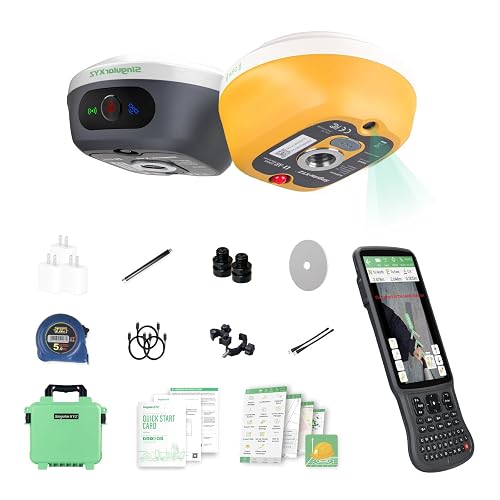
SingularXYZ L1-AR GNSS RTK Handheld Collector
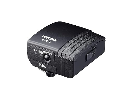
PENTAX O-GPS2 Handy GPS with ASTROTRACER
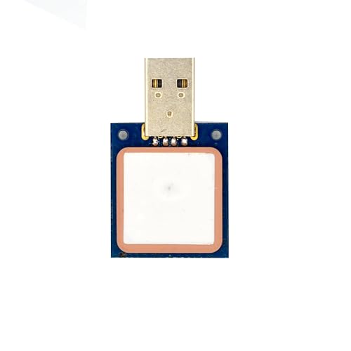
GPYes 2.0 u-blox 8 USB GPS Unit
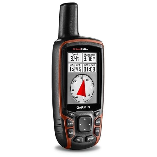
Garmin GPSMAP 64s Worldwide Handheld Navigator
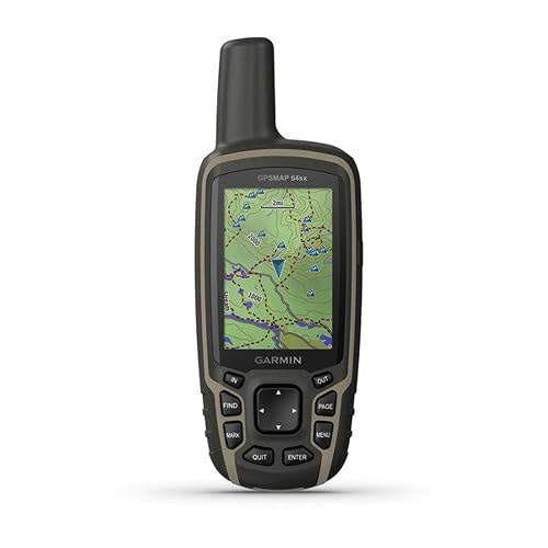
Garmin GPSMAP 64sx Handheld GPS with TopoActive Maps
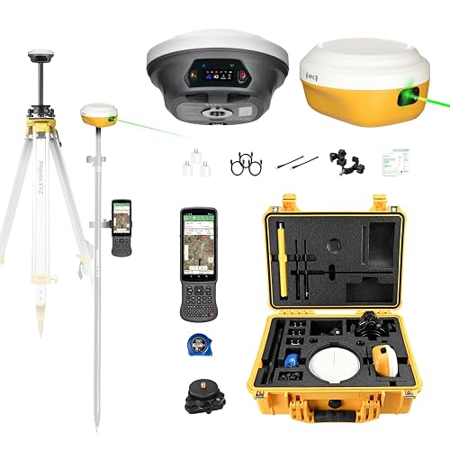
SingularXYZ E1 Pro-L1 Laser GPS Rover RTK System

SingularXYZ E1 Lite GNSS RTK Surveying System
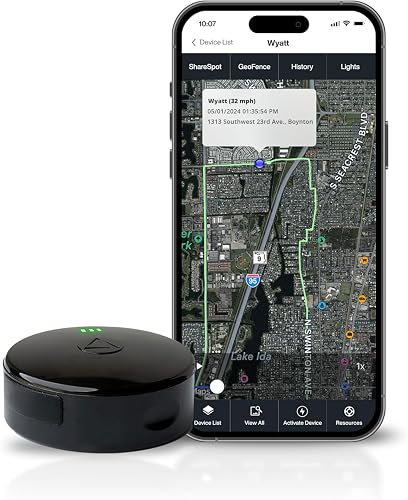
LandAirSea 54 GPS Tracker (Magnetic, Waterproof)
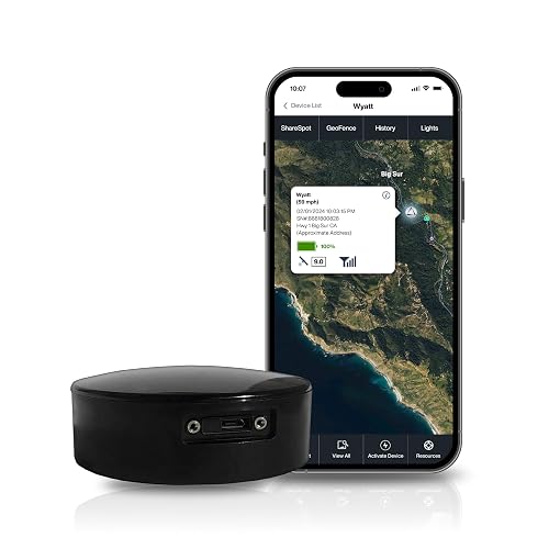
LandAirSea Overdrive GPS Tracker with Extended Battery

LandAirSea Sync 4G LTE OBD-II GPS Tracker
The Strengths Of Each Pick
Survey crews working in tight urban corridors or under heavy canopy know the usual frustration: satellites vanish behind tree cover or bounce off glass towers, and accuracy drops to unusable levels. The SingularXYZ L1-AR takes aim at that exact pain point with a 1408-channel L1/L2 GNSS engine (the hardware that listens to multiple satellite frequencies at once) capable of pulling in signals from GPS, GLONASS, Galileo, BDS, QZSS, and SBAS constellations simultaneously. That broad reception is what allows the unit to initialize in roughly five seconds and lock onto centimeter-level accuracy even when conditions aren’t ideal.
The standout trick, though, is the AR visual stakeout. A built-in global-shutter camera with a 2 MP sensor overlays virtual point guidance directly onto the live camera view, so the operator walks toward a target instead of staring at coordinates on a map. Compared to traditional paper-and-pole methods, this approach tends to speed up field layout substantially. Tilt surveying up to 120 degrees adds flexibility for awkward points, and bundled software handles the data side.
Useful Highlights
- 1408-channel multi-constellation engine delivers centimeter accuracy under canopy and in urban canyons
- AR camera overlay turns stakeout into a visual walk to the target rather than map-reading
- 120-degree tilt survey accommodates poles that aren’t perfectly plumb, saving time on tricky points
- Bundled software and included support shorten the learning curve for crews new to RTK workflows
Things To Consider
- RTK workflows demand a base station or network correction source, which adds setup complexity
- Heavy field use means battery management matters: charging routines and spare batteries become part of the kit
- Carrying both base and rover components adds weight to an already full survey bag
Made For
Professional surveying crews and civil engineering teams who need reliable centimeter accuracy in obstructed environments.
Skip It When
Casual hikers who only need turn-by-turn trail guidance will find the Garmin GPSMAP 64sx far simpler for recreational navigation.
The PENTAX O-GPS2 sits in a category almost no other product occupies: a camera-mounted GPS accessory built specifically for astrophotography. Slide it onto the hotshoe of a compatible Pentax DSLR and the unit feeds location data directly into the camera body, then uses that data plus an electronic compass to track celestial objects as they move across the night sky. The feature, called ASTROTRACER, lets photographers sidestep the star-trail blur that ruins long exposures of the Milky Way or deep-sky targets.
Unlike the L1-AR’s centimeter surveying focus, this device prioritizes simplicity for a creative workflow. It picks up GPS in the US, QZSS in Japan, GLONASS, and Galileo, which covers nearly any shooting location a traveling photographer might visit. The weather-resistant build handles dew and light drizzle common during night shoots. A simplified button layout keeps adjustments quick when you’re standing in the dark.
What It Does Well
- ASTROTRACER function tracks stars and celestial bodies, eliminating star trails on long exposures
- Multi-constellation reception covers GPS, GLONASS, Galileo, and QZSS for global shooting locations
- Weather-resistant construction shrugs off dew and light rain during overnight sessions
- Simple navigation and electronic compass provide basic waypoint logging for outdoor location shoots
Worth Noting
- Compatibility is limited to Pentax DSLR bodies with a hotshoe and ASTROTRACER support
- Battery life for a full night of shooting should be tested in advance, since cold temperatures drain cells faster
- The device won’t function as a standalone navigator the way a Garmin handheld would
Feature Snapshot
Right Fit For
Photographers shooting the night sky with Pentax DSLRs who want cleaner star images without a dedicated tracking mount.
Reach For A Different Pick When
Surveyors needing centimeter accuracy should pick the SingularXYZ L1-AR GNSS RTK Handheld Collector instead.
Sometimes a full handheld navigator is overkill. Hobbyists running mapping software on a laptop, pilots using flight sim software, or drivers wanting their aging notebook to recognize position data can plug the GPYes 2.0 into any USB port and instantly add GPS capability. The u-blox 8 chipset inside is the same family of receiver used in many commercial fleet and aviation products, and it tends to acquire satellites quickly even from a window-mounted laptop.
At roughly 4 x 2 x 0.2 inches, the unit barely registers in a laptop bag, and voice recognition support makes hands-free operation possible for navigation apps that accept spoken commands. Compared to the Garmin GPSMAP 64sx, which is built for trail navigation, this one is built for computers: there’s no screen, no buttons, no battery to charge. It draws power and passes data straight through the USB connection.
Bright Spots
- u-blox 8 chipset delivers accurate positioning with fast satellite acquisition
- USB connectivity works with smartphones, tablets, and computers across operating systems
- Slim 4 x 2 x 0.2-inch footprint slips into a laptop sleeve or jacket pocket
- Voice recognition adds hands-free convenience when paired with compatible navigation apps
Trade Offs
- No display means you’ll always need a paired device to view position data
- USB reliance limits use to situations where a host device with a free port is available
- Not designed for outdoor adventure use the way a rugged handheld would be
Whose Shelf It Belongs On
Hobbyists, flight sim enthusiasts, and laptop mappers who need positional data on a host device rather than a standalone navigator.
Look Elsewhere When
Backcountry hikers should grab the Garmin GPSMAP 64sx for its rugged body, sunlight-readable screen, and dedicated buttons.
The GPSMAP 64s has earned its place as a go-to handheld for serious hikers and hunters, and the core hardware still delivers. A 2.6-inch sunlight-readable color display remains one of the better screens for midday trail use, where glare washes out lesser displays. The high-sensitivity GPS and GLONASS receiver paired with a quad helix antenna pulls in satellites reliably under tree cover and in steep terrain where other units struggle.
A 3-axis electronic compass and barometric altimeter round out the navigation toolkit, giving you heading data even when standing still and altitude readings that double as a weather trend indicator. Wireless connectivity allows sharing waypoints with compatible units, and TOPO U.S. 24K map support plus a year of Birdseye Satellite Imagery make pre-trip planning richer. Compared to the newer GPSMAP 64sx below, the original 64s lacks preloaded TopoActive maps but often costs less.
Where It Excels
- Sunlight-readable 2.6-inch color display holds up under bright midday conditions
- Quad helix antenna improves reception in dense forests and narrow canyons
- 3-axis compass and barometric altimeter provide heading and weather trend data
- Wireless sharing with compatible units simplifies group trip coordination
Points To Note
- No preloaded topographic maps means you’ll want to load your own before heading out
- Charging and battery replacement routines matter on multi-day trips away from power
- Older model year means map and software updates may taper sooner than newer units
Key Product Details
Who Should Grab It
Hikers, hunters, and search-and-rescue volunteers who prioritize reliable reception and a readable screen over touchscreen interfaces.
Swap It Out When
Anyone wanting preloaded maps right out of the box should consider the Garmin GPSMAP 64sx instead.
The GPSMAP 64sx takes everything the earlier 64s offers and adds one feature that matters enormously to backpackers: preloaded TopoActive maps. Turn it on, and the screen renders routable trails, elevation contours, and points of interest without a long upload session at home. For multi-day backpackers who want to spend planning time on route logic rather than file management, this convenience alone justifies the upgrade.
Multi-GNSS support means the receiver listens to GPS and GLONASS together for faster, more accurate fixes, especially useful in northern latitudes or heavy canopy. A 2.6-inch sunlight-readable color display, rugged water-resistant body, and button-driven operation make the unit glove-friendly in cold weather where touchscreens misbehave. The black-and-tan color scheme hides scuffs better than all-black housings, which trail users tend to appreciate.
Positive Takeaways
- Preloaded TopoActive maps get you on the trail without a separate map-loading session
- Multi-GNSS reception improves fix speed and accuracy in challenging terrain
- Rugged water-resistant build handles rain, snow, and accidental drops
- Button operation works well with gloves and in freezing conditions
Room For Improvement
- No touchscreen means entering waypoints by hand is slower than on modern phone apps
- Screen size remains modest for users accustomed to large phone displays
- Battery type and life depend heavily on settings, so cold-weather users should pack spares
Technical Highlights
Best Suited To
Multi-day backpackers and thru-hikers who want ready-to-go topographic detail without preliminary map uploads.
Where Another Pick Suits Better
Astrophotographers should choose the PENTAX O-GPS2 Handy GPS, since that’s the category where it delivers unique value.
Traditional GNSS rovers can’t measure points they can’t physically reach: the top of a building, a slope above a cliff, a utility pole in a fenced enclosure. The E1 Pro-L1 solves that with a hybrid approach, pairing full-constellation GNSS tracking with an integrated laser rangefinder that measures inaccessible targets up to 10 meters away. For surveyors working in tight urban sites or hazardous terrain, this combination can replace multiple specialized tools.
A 1.1-inch HD touchscreen remains readable in direct sun, and the AR stakeout overlay guides operators to target points visually rather than by coordinate math alone. Bluetooth, NFC, PPK (Post-Processed Kinematic), and NTRIP (network RTK corrections over internet) connectivity cover most modern data workflows, and 15-kilometer UHF radio range supports long-baseline setups. The included tribrach lets the unit mount to standard surveying poles, and it can act as a base station for drone surveying operations.
The Case For It
- Laser plus GNSS hybrid captures points unreachable by pole alone, saving time on awkward sites
- 15-kilometer UHF range enables long-baseline setups between base and rover
- Functions as a base station for drone surveying workflows, broadening utility
- Sunlight-readable HD touchscreen reduces squinting during midday field operations
A Few Limitations
- Hybrid functionality adds complexity, which means a steeper learning curve than GNSS-only units
- Long battery days require disciplined power management on remote sites
- The included tribrach and accessories add to overall kit weight and transport logistics
Who Will Love This
Surveying professionals and drone-mapping crews who need hybrid laser and GNSS capability on complex job sites.
Not Your Match When
Casual recreational users would do better with the Garmin GPSMAP 64sx, which serves trail navigation without the survey workflow overhead.
Surveyors running long days away from power outlets know that battery anxiety can ruin a workday. The E1 Lite attacks that problem head-on with a 6700 mAh battery that supports over 20 hours of continuous operation on a single charge. For crews running dawn-to-dusk boundary or topographic surveys, that endurance means no mid-day scramble for a vehicle inverter or spare power bank.
An integrated IMU (Inertial Measurement Unit) initializes in five seconds and supports tilt measurements up to 60 degrees, so surveyors don’t need to level the pole perfectly for every shot. The 1408-channel GNSS engine handles full-constellation tracking, and the unit functions as both base and rover. Compatibility with standard 5/8-inch thread poles keeps mounting simple. Type-C charging means the same cable used for a phone can top off the unit at the trailhead.
Key Advantages
- 6700 mAh battery delivers 20-plus hours of continuous fieldwork on a single charge
- IMU-based tilt surveying up to 60 degrees speeds up point capture without leveling the pole
- Functions as both base station and rover, reducing total kit investment
- Standard 5/8-inch thread compatibility fits existing surveying poles
Honest Caveats
- RTK corrections still require either a network connection or a second unit acting as base
- Cold-weather operation can reduce effective battery capacity, so winter crews should monitor levels
- Total kit weight with pole, controller, and base hardware adds up on long hikes between points
Feature Rundown
Perfect Match For
Surveying crews running full-day boundary or topographic jobs where battery life and IMU-assisted tilt capture save time.
Consider Something Else When
Backpackers and casual explorers will find the Garmin GPSMAP 64sx more approachable for recreational navigation.
The LandAirSea 54 shifts the conversation from handheld navigation to asset tracking, and it’s built for a completely different use case. A strong magnetic base lets the unit attach discreetly underneath a vehicle, inside a wheel well, or on the frame of a trailer or piece of equipment. The waterproof housing handles rain, snow, and brief submersion, which matters for outdoor-stored assets.
Real-time tracking through web-based software or the SilverCloud app shows location updates as frequently as every three seconds, with historical playback available for up to a year. Geofencing alerts notify you when an asset enters or exits a defined area, a useful feature for monitoring teen drivers or company vehicles. Note that a subscription is required for service, so total cost of ownership extends beyond the hardware price.
Everyday Perks
- Strong magnetic mount attaches quickly to vehicle frames and equipment without brackets
- Waterproof housing survives rain, snow, and brief submersion scenarios
- Updates as fast as every three seconds for near-real-time asset visibility
- Geofencing alerts flag unexpected movements across user-defined zones
Points To Keep In Mind
- A subscription is required for service, adding ongoing cost beyond the hardware purchase
- Battery life depends heavily on update frequency, with faster intervals draining cells sooner
- Cellular coverage gaps in remote areas can interrupt tracking continuity
Built With In Mind
Vehicle owners, small-fleet operators, and parents who want ongoing location visibility for cars, ATVs, or other mobile assets.
A Better Fit Elsewhere
Surveying professionals should pick the SingularXYZ E1 Lite GNSS RTK System, which is built for centimeter-accuracy fieldwork.
The Overdrive takes the LandAirSea 54 formula and stretches it for commercial-grade deployments. The headline upgrade is the extended-life battery, which supports longer intervals between recharges: a meaningful improvement when the tracker is mounted on a trailer, container, or piece of construction equipment that may sit idle for weeks. International tracking across more than 155 countries also makes the unit viable for cross-border logistics operations.
Setup is straightforward, with the unit working right out of the box within minutes of activation. The same SilverCloud app and web-based software used by the LandAirSea 54 manage tracking, geofencing, and historical playback. Compared to its sibling, the Overdrive sacrifices some update frequency to extend battery life, which suits applications where long endurance matters more than second-by-second precision.
Well-Handled Touches
- Extended battery supports long deployments on trailers and idle equipment
- International tracking across 155-plus countries supports cross-border logistics
- Magnetic and waterproof build handles the same harsh mounting environments as the 54
- Quick setup minimizes downtime when outfitting new assets
Some Limits To Know
- A subscription is required, just like with the LandAirSea 54
- Extended battery life may come at the cost of less frequent position updates
- Cellular dead zones in remote industrial yards can interrupt tracking signals
Who It Suits Best
Commercial fleet operators and logistics managers who need long battery life and international coverage for trailers and equipment.
Where Another Pick Suits Better
Casual vehicle owners who only need basic location tracking should consider the LandAirSea 54, which costs less.
The Sync takes a different approach from the magnetic LandAirSea trackers. Instead of sticking under a vehicle, it plugs directly into the OBD-II port (the standardized diagnostic connector found in most cars and light trucks built after 1996). That makes installation essentially instant: locate the port, plug in the unit, and the tracker draws power from the vehicle’s electrical system. No batteries to charge, no magnets to attach.
4G LTE connectivity supports real-time tracking with updates every three seconds and historical playback for up to a year. Geofencing and real-time alerts work through the same SilverCloud app and web platform. The compact, discreet design hides the tracker from casual view, which appeals to parents monitoring teen drivers or small businesses keeping tabs on company vehicles. Like other LandAirSea units, a subscription is required for service.
Good Reasons To Consider
- OBD-II plug-and-play setup takes seconds and requires no tools or wiring
- Vehicle-powered operation eliminates battery recharging routines
- 4G LTE connectivity supports fast, reliable updates across cellular coverage areas
- Discreet form factor hides easily under the dashboard for unobtrusive tracking
Things To Weigh
- Requires a compatible OBD-II port, which excludes most heavy-duty trucks and older vehicles
- Subscription cost adds to total ownership over the life of the device
- Removing the tracker is as easy as unplugging it, which may matter for tamper-prone installations
Made For
Light-duty fleet managers, parents, and small-business owners who want hassle-free vehicle tracking without battery management.
Skip It When
Owners tracking trailers, construction equipment, or assets without an OBD-II port should pick the LandAirSea Overdrive instead.
What Matters Most Before Choosing Handheld Gps Units
Matching the Device to the Job
Handheld GPS devices break into roughly four families, and the right pick depends on which one matches your work. Recreational navigators want sunlight-readable screens, rugged buttons, and preloaded topographic maps for trail use. Surveyors and engineers want centimeter accuracy, RTK (Real-Time Kinematic) correction support, and IMU-assisted tilt measurement. Photographers want camera-mounted star tracking. Asset managers want cellular-connected trackers with magnetic or OBD-II mounting.
Pick the wrong family, and you’ll either overpay for capability you’ll never use or struggle with a unit that lacks the precision your work demands. A surveyor who buys a recreational handheld will find meter-level accuracy insufficient for boundary work. A hiker who buys an RTK rover will carry five pounds of gear for a feature set they don’t need.
Key Specs That Actually Matter
Satellite constellation support affects how quickly and reliably a unit locks onto position. GPS alone works in most of North America, but adding GLONASS, Galileo, or BDS improves fixes in northern regions and urban environments. Channel count (hundreds or thousands) indicates how many satellite signals the receiver can track simultaneously. Higher numbers generally mean faster, more reliable fixes under challenging conditions.
Battery type and capacity matter more than most buyers realize. Fieldworkers away from power need units that last a full workday or carry spare batteries. Charging port standards affect cable compatibility: USB Type-C is increasingly common and convenient. For trackers, update frequency and battery life trade off against each other; faster updates drain cells faster.
Build Quality and Environmental Ratings
Water resistance ratings, drop resistance, and operating temperature ranges matter for outdoor use. Survey and trail units should handle rain, dust, and the occasional drop onto rocks. Camera-mounted accessories need weather resistance for night-shoot dew. Trackers need waterproof housings if they sit underneath vehicles exposed to road spray and standing water.
Software, Maps, and Connectivity
Preloaded maps save hours of preparation, while aftermarket map support lets you tailor content to specific regions. Wireless connectivity (Bluetooth, Wi-Fi, ANT+) simplifies data transfer between units and phones. For survey work, NTRIP compatibility enables network-based RTK corrections over cellular internet.
Key Considerations Across These Picks
Pitfalls Shoppers Hit
The most common mistake is matching a unit to the wrong family. Buying a recreational handheld for survey work yields disappointing accuracy, and buying an RTK rover for casual trail use means hauling unnecessary weight. Another trap is overlooking subscription costs for cellular trackers: the hardware price looks reasonable, but monthly fees compound over years. Buyers also sometimes ignore update frequency on trackers, then find that real-time every-three-second reporting drains the battery far faster than expected.
A third pitfall is ignoring charging and cable standards. Units with proprietary connectors can leave you hunting for a spare cable in a hotel room, while USB Type-C models tend to play nicely with gear you already carry. Map and software update policies matter too; older units may stop receiving feature updates sooner than newer models.
What Separates Premium From Basic
Higher-tier units in this category earn their price through accuracy, sensor integration, and build quality. RTK rovers with 1408-channel engines and IMU tilt support cost more because the hardware delivers centimeter accuracy in conditions where basic handhelds struggle to maintain a fix. Survey-grade devices also bundle support and software that shorten the learning curve.
For trackers, the premium tier buys longer battery life, international coverage, and faster update frequencies. For recreational handhelds, the upgrade typically pays for preloaded maps, wireless connectivity, and tougher housings. The honest read: pay more when the unit directly affects professional output or asset protection, and save when the use case is casual or recreational.
Frequently Asked Questions
What is RTK and why does it matter?
RTK stands for Real-Time Kinematic, a positioning technique that uses correction data from a base station or network to achieve centimeter-level accuracy, far better than the meter-level accuracy of standard GPS. It matters for surveyors, engineers, and anyone whose work depends on precise coordinates.
Can a handheld GPS unit work without cell service?
Yes, most recreational handhelds rely on satellite signals alone and function without cellular coverage. Survey units often use radio links or UHF for base-to-rover communication, while asset trackers typically require cellular service for real-time updates.
How long do handheld GPS batteries last?
Battery life varies widely by model and use. Trail handhelds often run 16 to 25 hours on standard settings, while survey units with IMU tilt and high update rates may drain faster. Asset trackers with frequent updates may need recharging every few days, while long-life models can last weeks or months.
Do I need a subscription for GPS tracking devices?
Asset trackers from LandAirSea and similar brands typically require a subscription for cellular data service, which enables real-time tracking and historical playback. Handheld navigators and survey units generally do not require subscriptions, though map updates may carry separate fees.
Are handheld GPS units still worth buying in 2026?
Yes, especially for users who venture beyond cell coverage, work in remote terrain, or need accuracy beyond what phones provide. Dedicated units offer better reception, longer battery life, and rugged construction suited to outdoor conditions.
Closing Remarks
The right handheld GPS unit depends almost entirely on what you’re doing with it. Surveyors chasing centimeter accuracy will gravitate toward the SingularXYZ RTK systems. Hikers and backpackers will find the Garmin GPSMAP lineup reliable and familiar. Astrophotographers need a PENTAX O-GPS2, and fleet managers want a LandAirSea tracker that matches their deployment style. Pick the family that fits your work, confirm the specs line up with your real-world conditions, and the rest tends to fall into place.